VĂN HÓA ONLINE – TÀI LIỆU - THỨ HAI 25 MAR 2024
Nhà báo Lý Kiến Trúc tường trình Hội nghị Biển ở Manila 2015:
"Tố cáo Trung Quốc xâm chiếm biển đảo Đông Nam Á"
02 Tháng Tư 2015 9:09 CH(Xem: 2834)
"NHẬT BÁO VĂN HÓA - CALIFORNIA" THỨ SÁU 03 APRIL 2015

LÝ KIẾN TRÚC
tường trình từ Manila-Philippines
Nhà báo Lý Kiến Trúc tường trình Hội nghị Quốc tế Biển Đông ở Manila 27 March, 2015.
Hội nghị Manila về Biển Đông và Vai trò của các Xã hội Dân sự
https://www.nhatbaovanhoa.com/a2532/hoi-nghi-manila-ve-bien-dong-va-vai-tro-cua-cac-xa-hoi-dan-su
Gs Nguyễn Ngọc Bích đột ngột qua đời trên chuyến bay đi Manila dự Hội nghị Biển Đông
Phỏng vấn Thượng nghị sĩ Roilo Golez, cựu Cố vấn An ninh Quốc gia Philippines
 Phái đoàn Việt Mỹ đi tham dự Hội nghị Quốc tế về Biển Đông tại Manila Philippines - Từ trái: Gs Nguyễn Ngọc Bích và phu nhân Tiến sĩ Nguyễn Thị Hợi từ Hoa Kỳ; nhà báo Từ Thức từ Paris, Gs Đoàn Viết Hoạt và phu nhân Gs Nguyễn Thị Thức từ Hoa Thịnh Đốn, Hoa Kỳ; một thân hữu. Ảnh Lý Kiến Trúc, nhà báo từ California, trong một bữa ăn sáng tại khách sạn City Garden Hotel, Makati, Manila ngày 25/3/2015.
MANILA (VH) - Gần 40 tham dự viên, quan sát viên, các tổ chức Xã hội Dân sự - Dân chủ, và các nhân vật nổi tiếng quốc tế đến tham dự, tham luận, hội thảo ngày "Hội nghị Quốc tế về Tranh chấp biển Đông Nam Á - International Conference on the Southeast Asia Sea Disputes" tại hội trường Ateneo Law School, Makati, thủ đô Manila, Philippines vào ngày 27 tháng 3, 2015.
Ban tổ chức gồm có:
- US Pinoys for Good Governance (USP4GG);
- DI KA Pasisiil (Pinoy Patriots United);
- Institute for Maritime Affairs & Law of the Sea (UP);
- Họp Mặt Dân Chủ (HMDC);
- VOICE (Vietnamese Overseas Initiative for Conscience Empowerment).
Các diễn giả đến từ các quốc gia hiện diện:
- Cựu Cố vấn An ninh Quốc gia Philippines Roilo Golez (Philippines);
- Tiến sĩ Carlyle A. Thayer (Australia);
- Tiến sĩ Celia Belocora-Lamkin (USA);
- Tiến sĩ Sophie Boisse au du Rocher (France);
- Học giả Francois-Xavier Bonnet (France);
- Tiến sĩ Jay L. Batongbacal (Philippines);
- Phó Đề đốc Nhật bản Ota Fumio (Japan);
- Giáo sư Nguyễn Ngọc Bích (W. DC. Vietnam Oversea);
- Tiến sĩ Trần Huy Bích (UCLA-Vietnam Oversea);
- Thạc sĩ Hoàng Việt (ViệtNam);
- Học giả Nguyễn Đình Đầu (Việtnam).
Ngoài các diễn giả ở các quốc gia đến với tư cách cá nhân, hầu như các tham dự viên đều là thành viên của tổ chức VOICE (Ls Trịnh Hội), tổ chức Họp Mặt Dân Chủ (Gs Đoàn Viết Hoạt). Không thấy có tham dự viên người Phi Luật Tân. Các cơ quan truyền thông báo chí có đài truyền hình số 5 - Philippines, Pacific News, đài RFA và báo Văn Hóa Online.
Diễn giả
Đúng 9 giờ sáng, Luật sư Trịnh Hội, Giám đốc điều hành VOICE, đồng tổ chức hội nghị ngỏ lời chào mừng quan khách, và giới thiệu người điều hợp chương trình hội nghị - hội thảo đầu tiên là ông Jeremy Barns, Giám đốc National Museum of the Philippines.
Ông Jeremy Barns giới thiệu chương trình thứ nhất (a) gồm có: vị diễn giả đầu tiên là cựu Cố vấn An ninh Quốc gia Philippines, cựu Thượng nghị sĩ Roilo Golez (1a. Xem toàn văn tham luận đính kèm); Diễn giả thứ hai là Tiến sĩ Celia B. Lamkin, thuộc US Pinoys for Good Governance, Marianas Chapter (CNMI and Guam) (2a. Xem toàn văn tham luận đính kèm), Diễn gỉa thứ ba là Tiến sĩ Jay Batongbacal thuộc Viện Hàng hải, Giáo sư về Luật biển Đại học Philippines. Sau ba bài thuyết trình là phần thảo luận dành cho các tham dự viên đặt câu hỏi.
Người điều hợp chương trình thứ hai (b) là ông Đặng Đình Khiết, thành viên tổ chức Họp Mặt Dân Chủ. Ông Khiết mời Diễn giả đầu tiên là Giáo sư Nguyễn Ngọc Bích, Chủ tịch Nghị hội toàn quốc Việt - Mỹ (1b. Xem toàn văn tham luận đính kèm); Diễn gỉa thứ hai là Thạc sĩ Hoàng Việt, Đại học Luật khoa Sàigon-Việt Nam (2b. Xem toàn văn tham luận đính kèm); Diễn giả thứ ba là Tiến sĩ Trần Huy Bích, Thư viện Đại học UCLA (3b. Xem toàn văn tham luận đính kèm); Diễn giả thứ tư là Học giả Nguyễn Đình Đầu, nhà nghiên cứu Biển độc lập Việt Nam(Vì tuổi cao, ông Đầu không qua Manila chỉ gởi slide show thuyết minh một số hình ảnh, tư liệu biển Đông; Slide Show này giao cho ông Đoàn Viết Hoạt, không phổ biến). Sau ba bài thuyết trình là phần thảo luận dành cho các tham dự viên đặt câu hỏi.
Người điều hợp chương trình thứ ba (c) là Giáo sư Đoàn Viết Hoạt, Chủ tịch Viện Quốc tế-ViệtNam. Ông Hoạt mời vị Diễn giả đầu tiên là Tiến sĩ Carlyle A. Thayer, Viện Đại học New South Wales đến từ Úc châu (1c. Xem toàn văn tham luận đính kèm); Diễn giả thứ hai là Tiến sĩ Sophie Boisseau du Rocher đến từ Pháp quốc (2c. Xem toàn văn tham luận đính kèm); Diễn giả thứ ba là Tiến sĩ Ota Fumio, nguyên Phó Đề đốc Hải quân Nhật đến từ Nhật bản (3c. Xem toàn văn tham luận đính kèm); Diễn giả thứ tư là Tiến sĩ Francois-Xavier Bonnet đến từ Pháp quốc. Sau bốn bài thuyết trình là phần thảo luận dành cho các tham dự viên đặt câu hỏi.
Bước qua phần thứ tư của chương trình là phần hội thảo thông qua "Bản Tuyên bố chung và thành lập nhóm Công tác Xã hội Dân sự - Adoption of Joint Statement and Establishment of Joint Civil Society Working". Bản Tuyên bố chung đã được ban tổ chức đánh máy sẵn, in ra phát cho các diễn giả và các tham dự viên. Cuộc thảo luận diễn ra có phần sôi nổi do sự đóng góp tích cực của các thành viên Họp Mặt Dân Chủ (HMDC) vàVOICE.
Vai trò Xã hội Dân sự trong việc tranh chấp biển Đông
Phần thứ tư của ngày "Hội nghị Quốc tế về Tranh chấp biển Đông Nam Á - International Conference on the Southeast Asia Sea Disputes" là phần kết thúc quan trọng của hội nghị. Phần này, ban tổ chức đưa ra một bản"Tuyên bố chung" (đã đánh máy sẵn). Nội dung Tuyên bố chung chia làm hai phần: phần đầu đánh giá tầm quan trọng của "Biển Đông" đối với Việt Nam và "Biển Tây - West Philippine Sea" đối với Philippines, trong việc duy trì hòa bình, an ninh và phát triển trong khu vực. Tuyên bố chung khẳng định đường lưỡi bò 9 đoạn do Trung Hoa tự vẽ không có giá trị pháp lý. Nhấn mạnh vai trò của các nhóm Xã hội Dân sự Việt - Phi phải được tham gia vào các cuộc thảo luận tranh chấp. Vì vậy:
Phần hai của bản Tuyên bố chung đề xuất 5 điểm. (1d. Xem toàn văn bản Tuyên bố chung đính kèm). Hội nghị đưa ý kiến đổi tên vùng biển đang tranh chấp thành biển " Đông Nam Á"; ủng hội một Ủy ban Quốc tế độc lập giải quyết các tranh chấp; phản đối những hành vi xâm chiếm, xây dựng quy mô biển đảo của Trung Quốc ở khu vực biển đảo Trường Sa, tố cáo Trung Quốc đã trắng trợn vi phạm Luật biển quốc tế (UNCLOS).
Trong phần thảo luận, một tham dự viên là ông Lâm Đăng Châu (thành viên nhóm HMDC) mạnh mẽ phát biểu ủng hộ 5 điểm trong Bản Tuyên bố chung. Phát biểu của ông Châu được đa số vỗ tay đồng tình. Ông Châu đề nghị Giáo sư Nguyễn Ngọc Bích với vai trò là người điều hợp tuyên đọc Bản Tuyên bố trước các diễn giả, trước sự chứng kiến của mọi người tham dự và thay mặt mọi người ký vào bản Tuyên bố chung. Mọi người vỗ tay đồng tình. Tuy nhiên, một số diễn giả tỏ ra hơi "ngỡ ngàng" trước sự "đột biến" của phần thứ tư cũng là phần cuối cùng của ngày hội nghị diễn ra từ 9 giờ sáng đến 5 giờ chiều.
Kết quả của "Hội nghị Quốc tế về Tranh chấp biển Đông Nam Á - International Conference on the Southeast Asia Sea Disputes" là một điểm son mang lại cho ban tổ chức Phi-Việt, đặc biệt hai ban đồng tổ chức là VOICE và HMDC đã quy tụ được một diễn đàn rộng rãi với sự tham dự - tham luận của nhiều nhân vật quốc tế.
Qua hội nghị, mối liên kết giữa nhóm VOICE và nhóm HMDC củng cố chặt chẽ. (Trong lời chào mừng thân hữu đế dự chung vui ở "tổng đàn" của VOICE ở Manila, ông Đoàn Viết Hoạt và Trịnh Hội đã chia sẻ những khóa học về Xã hội Dân sự cho hàng chục thành viên trẻ trong và ngoài nước. Riêng ông Hoạt cho biết tổ chức Họp Mặt Dân Chủ (HMDC) sau nhiều năm hoạt động ở hải ngoại nay đã quy tụ được gần trăm thành viên dân chủ.
Tuy nhiên, ( tuy khá bất ngờ), qua hội nghị, việc hình thành để tạo sự liên kết với nhóm Xã Hội Dân sự Philippines là điều mới mẻ.Điển hình cựu Cố vấn An ninh Quốc gia Roilo Golez đã cùng với Giáo sư Nguyễn Ngọc Bích cùng ký kết trong Bản Tuyên bố chung với tư cách là đồng tổ chức để "thiết lập một Nhóm Công tác Xã hội dân sự" (điểm 5 trong Tuyên bố chung).
Bốn nhân vật ghi sẵn tên ký trong bản Tuyên bố là Tiến sĩ Celia B. Lamkin (US Pinoys for Good Governace); Giáo sư Nguyễn Ngọc Bích (Họp Mặt Dân Chủ Vietnam Democratic Assembly); Cựu Cố vấn An ninh Quốc gia Philippines Roilo Golez (DI KA Pasisiil Movement - Pinoy Patriots United) và Ls Trịnh Hội (VOICE).
Trên bàn chủ tọa, những phút cuối cùng, chỉ có hai ông Bích và Golez lần lượt ký vào bản Tuyên bố chung, ngoài ra không thấy vị diễn giả nào khác ký.
Điểm khá ấn tượng trong thảo luận vào giờ cuối của hội nghị là vấn đề nêu lên sự thay đổi danh xưng vùng biển rộng 3.500.000 km2 (1.400.000 sq mi) thường được dùng bấy lâu nay trong các hội nghị và trong các văn kiện quốc tế là: "biển Đông"; "biển Đông Nam Á"; "biển Việt Nam-Trung Quốc"; "biển South China Sea"; "biển Tây Philippines". Bản Tuyên bố chung đề nghị được gọi thống nhất là khu vực "biển Đông Nam Á" (Southeast Asia Sea). Qua sự thăm dò, các vị diễn giả Pháp, Úc, Nhật, Phi, Hoa Kỳ cho biết, họ ghi nhận cao và sẽ thảo luận về ý kiến danh xưng khu vực biển "Đông Nam Á".
Tạm kết
Trong sinh hoạt chính trị của tập thể người Việt hải ngoại trước đây, cao trào đòi hỏi Đa nguyên Đa đảng cho Việt Nam dâng lên mạnh mẽ, nhưng dạo này, cao trào đa nguyên đa đảng dường như đã "lặng" xuống nhường chỗ cho Xã hội Dân sự. Theo dõi tình hình Việt Nam, đã có một vài Ủy viên Bộ chính trị đảng CSVN lên tiếng chắc nịch sinh hoạt chính trị ở VN hiện thời không có chuyện đa nguyên đa đảng, nhưng thực tế, nhiều tiếng nói phản biện trong nước nổi cộm lên dù nhà cầm quyền ra tay trấn áp.
Để bù lắp vào tư duy thời sự chính trị, phong trào "Xã hội Dân sự" hải ngoại và quốc nội trở thành điểm tụ của các nhân vật bất đồng chính kiến. Trong nước đã có độ hơn hai chục tổ chức Xã hội Dân sự; ngoài nước khá hiếm hoi. Qua hội nghị Manila, tiếng nói của nhóm Họp Mặt Dân Chủ hy vọng sẽ được góp mặt, góp tiếng trên bàn cờ tranh chấp chủ quyền biển đảo biển Đông mà bản Tuyên cáo đề nghị là biển "Đông Nam Á".
Từ ngày 18 tháng 4 năm 12014, trong chuyến đi quan sát 10 ngày đêm ở quần đảo Trường Sa, báo Văn Hóa đã đưa tin về danh xưng vùng biển Đông đã được gọi là "Biển Việt Nam-Trung Quốc" qua bản thông cáo ký kết giữa ông Lê Hồng Anh và ông Lưu Vân Sơn dưới sự chứng kiến của Chủ tịch Tập Cận Bình tại Bắc Kinh ngày 27 tháng 8, 2014.
Nhân chuyến ghé thăm Ấn Độ hôm 03/03/2015, Đô đốc Mỹ Harry Harris Jr, Tư lệnh Hạm đội Thái Bình Dương Mỹ trong một lời nhắn gởi trực tiếp đến Ấn Độ xác định rằng Biển Đông là vùng biển quốc tế chứ không phải là lãnh hải của riêng nước nào : « Ấn Độ được quyền hoạt động tự do ở bất cứ nơi nào mà mình muốn. Nếu nơi đó là Biển Đông thì cứ việc đến hoạt động ở đó. »
Nhận định của giới quan sát chính trị cho rằng, sự hình thành và hoạt động các tồ chức Xã hội Dân sự hy vọng sẽ là một sinh lộ mới, một sinh khí mới "phù hợp hơn" với tiến trình dân chủ hóa VN; "hội nhập hơn" với tiếng nói của xã hội Việt Nam đang dâng lên mạnh mẽ, biến đổi khôn lường, và, có thể, ít bị "trấn áp" hơn./
Lý Kiến Trúc / www.nhatbaovanhoa.com
tường trình từ Manila, 27 March, 2015
XEM THÊM:
- Tham luận của các diễn giả.
- Phỏng vấn Gs Nguyễn Ngọc Bích.
- Phỏng vấn Ls Trịnh Hội.
- Phỏng vấn Thạc sĩ Hoàng Việt.
- Phỏng vấn cựu Cố Vấn Roilo Golez.
HÌNH ẢNH HỘI NGHỊ
 Luật sư Trịnh Hội, Giám đốc điều hành VOICE chào mừng quan khách khai mạc hội nghị tại Manila.
 Ông Jeremy Barns, điều hành phần tham luận đầu tiên của các diễn giả trên bàn chủ tọa (từ trái): cựu Cố vấn An ninh Quốc gia Philippines Thượng nghị sĩ Roilo Golez; Tiến sĩ Jay Batongbacal; Tiến sĩ Celia B. Lamkin. Người ngồi phía dưới đang ghi nhận là Tiến sĩ Carlyle A. Thayer.
 Cựu Cố vấn An ninh Quốc gia Philippines Thượng nghị sĩ Roilo Golez.
 Tiến sĩ Jay Batongbacal
 Tiến sĩ Jay Batongbacal thuyết trình về đường lưỡi bò 9 đoạn tự vẽ của trung Quốc.
 Tiến sĩ Celia B. Lamkin
 Ông Đặng Đình Khiết (góc trái), diều hợp phần tham luận thứ hai. TS Carl Thayer đang nêu vấn đề biển Đông với ba diễn giả trên bàn chủ tọa (từ trái): Gs Nguyễn Ngọc Bích; Thạc sĩ Hoàng Việt; Tiến sĩ Trần Huy Bích.
 Giáo sư Nguyễn Ngọc Bích đọc tham luận. Ngồi phía dưới là Phó Đề đốc Hải quân Nhật bản Ota Fumino và Tiến sĩ Carl Thayer.
 Thạc sĩ Hoàng Việt đọc tham luận.
 Tiến sĩ Trần Huy Bích thuyết minh về 5 tấm bản đồ cổ biển Đông ông đã sưu tập được từ thư viện UCLA.

BÀI THUYẾT TRÌNH VỀ 5 TẤM BẢN ĐỒ CỔ CỦA TS TRẦN HUY BÍCH SƯU TẬP Ở THƯ VIỆN ĐẠI HỌC UCLA
Các đảo tại quần đảo Hoàng Sa có thể được chia làm hai nhóm: phía Tây Nam là một nhóm có tên tiếng Anh là “Crescent Group,” tên tiếng Việt là “nhóm Trăng Khuyết,” “nhóm Nguyệt Thiềm,” hay “nhóm Lưỡi Liềm”; phía Đông Bắc là một nhóm có tên tiếng Anh là “Amphitrite Group,” tên tiếng Việt là “nhóm An Vĩnh” (theo tên một xã trên Cù lao Ré thuộc tỉnh Quảng Ngãi, quê hương của hải đội Hoàng Sa thời các chúa Nguyễn. Với âm mưu “Hán hóa” quần đảo này, người Trung Hoa gọi nhóm Trăng Khuyết là Yongle qundao 永樂群島 (Vĩnh Lạc quần đảo) và nhóm An Vĩnh là Xuande qundao 宣德群島 (Tuyên Đức quần đảo).

Vĩnh Lạc là niên hiệu của Minh Thành tổ Chu Đệ, vị vua thứ 3 của nhà Minh, cũng là người đã sai Chu Năng và Trương Phụ sang đánh nước ta đầu thế kỷ 15, với mệnh lệnh thiêu hủy hay tịch thu cho bằng hết những chứng tích văn hóa của dân tộc Việt. Tuyên Đức là niên hiệu của Minh Tuyên tông Chu Chiêm Cơ, vị vua thứ 5 của nhà Minh, người đã sai Liễu Thăng và Mộc Thạnh sang cứu viện cho Vương Thông khi viên tướng này bị quân ta vây chặt trong thành Đông Quan, đưa tới việc Liễu Thăng bị chém ở Chi Lăng và Mộc Thạnh cắm cổ chạy dài (“Thằng nhãi Tuyên Đức nhàm võ không thôi, lại sai đồ nhút nhát Thạnh Thăng đem dầu chữa cháy”—Bình Ngô đại cáo).

Sau khi chiếm được toàn thể quần đảo Hoàng Sa năm 1974, nhà cầm quyền Bắc Kinh đưa ra luận điệu: sự kiện hai nhóm đảo có tên là “Vĩnh Lạc quần đảo” và “Tuyên Đức quần đảo” cho thấy Hoàng Sa đã thuộc về Trung Hoa trễ nhất là từ đời nhà Minh. Họ giải thích là trong các triều vua Vĩnh Lạc và Tuyên Đức, Đô đốc Thái giám Trịnh Hòa, trong 7 lần đem một hạm đội thật lớn “hạ Tây dương” (xuống Nam hải, rồi qua eo biển Malacca sang Ấn độ dương, tới tận đông Phi châu) đã tới Hoàng Sa đặt tên đảo như thế để “xác lập chủ quyền.” Một số học giả Tây phương chấp nhận giả thuyết này vì nghe có vẻ có lý, cho rằng quần đảo Paracel đúng là đã “thuộc về Trung Hoa từ đầu đời nhà Minh,” trước thời các chúa Nguyễn ở VN.
Khi sang dự Hội nghị về Biển Đông ở Manila, gs. THB đem theo một số bản đồ trong
bộ “Trịnh Hòa hàng hải đồ” (bản đồ thuật lại hành trình trên biển của Trịnh Hòa). Những bản đồ này cho thấy Trịnh Hòa không hề tới khu vực đảo Hoàng Sa và Trường Sa như Bắc Kinh đã huênh hoang.

Tấm bản đồ ở trang 9 cho thấy sau khi rời khu vực đảo Hải Nam, Trịnh Hòa đi chéo biển để tới “Ngoại La Sơn, ”tức Cù lao Ré thuộc Quảng Ngãi của Việt Nam hiện nay, không tới khu vực Hoàng Sa ở giữa biển. Bản đồ có phác họa một bãi lớn gồm nhiều mỏm đá nhỏ chìm dưới mặt nước, ghi tên là “Thạch tinh thạch đường” (sao đá + ao nhỏ có thành bằng đá), được các nhà nghiên cứu về Biển Đông nhận ra là Macclesfield Bank và về sau Trung Hoa gọi là Trung Sa quần đảo. Bản đồ này cũng vẽ một khu vực ghi tên là “Vạn sinh thạch đường dự” (vạn mỏm đá từ những ao đá còn đang hoạt động) và kế đó là “Thạch đường” (ao nhỏ có thành bằng đá, chỉ các rạn san hô). Theo các nhà nghiên cứu cận đại, khu vực ấy là quần đảo Paracel (Hoàng Sa). Điều này cho ta thấy đoàn thuyền của Trịnh Hòa ý thức được rằng trên biển có những khu vực nguy hiểm nhưng đã tránh, tuyệt đối không tới gần. Lời chú trong bản đồ này ghi: “thuyền bình đại tinh tiêm ngoại quá” (thuyền bình yên đi qua bên ngoài những những mỏm nhọn của đám sao đá rộng lớn).
Điều này cũng hợp lý vì trong đoàn thuyền của Trịnh Hòa có những “bảo thuyền” (thuyền chở báu vật) gồm vàng bạc, tơ lụa, đồ gốm, đồ sứ … của Trung Hoa, để làm quà tặng vua chúa các nước nhỏ tại Đông Nam Á và trong khu vực Ấn Độ dương, hầu trao đổi lấy “cống phẩm” vua các nước tặng lại Hoàng đế Trung Hoa. Các chuyến “hạ Tây dương” của Trịnh Hòa nhằm mục đích ngoại giao, không có mục đích thám hiểm. Trịnh Hòa không có lý do để tới Hoàng Sa, mà với Trịnh lúc đó chỉ là “những mỏm từ những ao đá (rạn san hô) còn đang hoạt động.”

Tấm bản đồ ở trang 10 cho thấy đoàn thuyền của Trịnh Hòa men sát bờ biển Trung phần Việt Nam, đi giữa khoảng Cù lao Ré và bờ biển, để tới Tân Châu cảng của Chiêm Thành quốc (tức Qui Nhơn ngày nay), rất xa khu vực Hoàng Sa ở giữa biển.

Tấm bản đồ ở trang 11 vẽ lộ trình của đoàn thuyền sau khi rời kinh đô Chiêm Thành. Đoàn thuyền đã men sát bờ biển Trung phần Việt Nam, tới khu vực Vũng Tàu thuộc Nam phần Việt Nam hiện nay. Thuyền đi giữa Côn Lôn sơn (tức Côn sơn) và bờ biển Việt Nam để xuống Nam Dương. Sau đó thuyền đi qua gần đảo Borneo để tới đảo Java (thuộc Nam Dương), không hề léo hánh tới khu vực Trường Sa ở giữa biển.
Trong đoàn thuyền của Trịnh Hòa có một thông dịch viên tiếng Ả Rập. Đó là một người Trung Hoa theo Hồi giáo là Mã Hoan (Ma Huan 馬歡). Sau chuyến đi cuối cùng, Mã Hoan viết lại các hành trình trong một cuốn hồi ký ký sự là Doanh nhai thắng lãm (Yingyai Sheng lan 瀛涯胜览). Trong cuốn hồi ký này, Mã kể rõ những nơi đã đi tới, cho biết ở lại mỗi nơi bao nhiêu lâu, nhưng tuyệt không nói gì tới những chuyện “thám hiểm đảo,” “xác lập chủ quyền,” cùng những “Vĩnh Lạc quần đảo, Tuyên Đức quần đảo” (hay Tây Sa, Nam Sa …). Trong bản dịch Yingyai Shenglan sang tiếng Anh, học giả người Anh J.V.G. Mills đã dựa theo lời kể của Mã Hoan để vẽ lại đường đi của Trịnh Hòa. Bản đồ ông vẽ lại và được in trong cuốn Ying yai Sheng lan (The Overall Survey of the Ocean’s Shores) cũng cho thấy Trịnh Hòa đã đi sát bờ biển chứ không hề bén mảng tới khu vực Hoàng Sa, Trường Sa. Gs. THB cũng giới thiệu trước Hội nghị tấm bản đồ này.
Trong thế kỷ 19, Trung Hoa có một học giả nổi danh là Ngụy Nguyên (Wei Yuan 魏源).
Một trong những tác phẩm quan trọng của ông là bộ Hải Quốc Đồ Chí (Haiguo Tuzhi 海國圖志). Khi soạn bộ sách này, ông được sự bảo trợ và giúp đỡ tài liệu từ một người bạn quyền thế là Lâm Tắc Từ (Lin Zexu 林则徐), đại thần, khâm sai của triều Thanh. Trong bức bản đồ “Đông Nam dương các quốc duyên cách đồ” (bản đồ về những thay đổi cũ mới tại các nước ở Đông và Nam dương) in trong cuốn 3 của bộ sách này, ông đưa ra khá đầy đủ những tên cũ và mới của các quốc gia ở Đông và Nam Trung Hoa (như Cao Ly, Nhật Bản, Việt Nam, Chiêm Thành …), nhưng chỉ trình bày quần đảo Hoàng Sa (với tên Vạn lý trường sa = bãi cát dài vạn dặm) và quần đảo Trường Sa (với tên Thiên lý thạch đường = ao đá dài ngàn dặm) bằng một đám những điểm chấm nhỏ cùng một cỡ và giống hệt như nhau. Điều này cho ta thấy cho tới lúc đó, nửa sau của thế kỷ 19 (bộ sách được in ra trong những năm 1852-53), học giới Trung Hoa mà Lâm Tắc Từ và Ngụy Nguyên là đại diện, vẫn chưa biết gì về hai quần đảo này, chỉ coi là những vùng nguy hiểm trên biển cần phải tránh.
Trong khi đó, theo Lê Quý Đôn, các chúa Nguyễn đã cho hải đội Hoàng Sa khai thác trên quần đảo Hoàng Sa từ thề kỷ 17, các vua Gia Long, Minh Mạng đã cho người tới cắm cờ, dựng mốc, đo đạc, vẽ bản đồ, lập miếu, trồng cây … tại Hoàng Sa từ đầu thế kỷ 19. Việc ghi “Vạn lý trường sa” và “Thiên lý thạch đường” vào “Đông Nam dương các quốc duyên cách đồ” cũng cho thấy Ngụy Nguyên cùng học giới Trung Hoa lúc đó vẫn coi những bãi cát, bãi đá này thuộc về “các nước ở Đông và Nam dương” chứ không phải của Trung Hoa.
Gs. THB xuất trình tấm bản đồ này trước Hội nghị quốc tế ở Manila để chứng tỏ rằng lời tuyên bố của chính phủ Trung Hoa, “Trung Quốc đã thiết lập chủ quyền ở Tây Sa và Nam Sa từ cổ đại” là rất xa với sự thật.
 Ông Trịnh Trung và tài liệu của cụ Nguyễn Đình Đầu gởi từ VN qua tham dự hội nghị.
 Giáo sư Đoàn Viết Hoạt điều hợp phần tham luận thứ ba.
 Từ trái: Tiến sĩ Francois-Xavier Bonnet; Tiến sĩ Sophie Boisseau du Rocher; cựu Phó Đề đốc Ota Fumino; Tiến sĩ Carlyle A. Thayer.
 Tiến sĩ Francois-Xavier Bonnet đọc tham luận.
 Tiến sĩ Sophie Boisseau du Rocher đọc tham luận.
 Cựu phó Đề Đốc Ota Fumino đọc tham luận.
 Bức hình kỷ niệm trong giờ giải lao. Từ trái: Ts Batongbacal, Thượng nghị sĩ Roloi Golez, Gs Nguyễn Ngọc Bích, Tiến sĩ Celia B. Lamkin, Giám đốc Viện bảo tàng Quốc gia Phiippines Jeremy Barns và Luật sư Trịnh Hội.
 Ông Nguyễn Công Bằng, Chủ tịch Vì Dân Foundation đến tham dự hội nghị với tư cách quan sát viên và Ts Carl Thayer.
 Tiến sĩ Carlyle A. Thayer và nhà báo Nguyễn Văn Khanh Giám đốc RFA Tiếng Việt.
 Tiến sĩ Carlyle A. Thayer và nhà báo Lý Kiến Trúc Chủ nhiệm báo Văn Hóa Online.
+++++++++++++++++++++++++++++++++++
Nhà báo Lý Kiến Trúc tường trình Hội nghị Biển ở Manila (Bài 3): Tham luận của các Diễn giả
05 Tháng Tư 20158:09 CH(Xem: 2435)
"NHẬT BÁO VĂN HÓA - CALIFORNIA" THỨ HAI 06 APRIL 2015
Nhà báo Lý Kiến Trúc tường trình Hội nghị Biển ở Manila:
Bài 3:
Tham luận của các Diễn giả
1/ Tiến sĩ Carlyle A. Thayer: Acquiescing to China’s Assertiveness in the South China Sea: U.S. and Australian Policies of Not Taking Sides
2/ Tiến sĩ Phó Đề đốc Ota Fumio: Chinese Maritime Expansion: Strategy and Counter-measures (Summary)
3/ Tiến sĩ Sophie Boisseau du Rocher: The EU and the South China Sea Issue : wishful thinking or real added value?
4/ Học giả Bill Hayton: Mistranslation and misunderstanding – the unlikely origins of China’s ‘U-shaped line’ claim in the South China Sea.
5/ Giáo sư Nguyễn Ngọc Bích: Toward a Peaceful Solution to The Conflict in The Southeast Asia Sea.
6/Tiến sĩ Trần Huy Bích: Giải thích việc phát hiện 5 tấm bản đồ cổ ở Đại học UCLA.
7/ Thạc sĩ Hoàng Việt: Institutions and methods for resolving maritime territorial disputes under international law.
8/ Tiến sĩ Phạm Cao Dương: Tác giả danh xưng biển "Đông Nam Á" vì sao không đến được Hội nghị Manila.
9/ Thông cáo chung Hội nghị Quốc tế về Biển ở Manila: VIETNAM PHILIPPINES
CIVIL SOCIETY - JOINT STATEMENT ON THE SOUTH CHINA SEA.

Một trong 5 bức bản đồ cổ do Tiến sĩ Trần Huy Bích phát hiện.
+++++++++++++++++++++++++++++++++++++
Acquiescing to China’s Assertiveness in the South China Sea: U.S. and Australian Policies of Not Taking Sides

Tiến sĩ Carlyle A. Thayer đọc tham luận.
(Summary)
In 1992 and again in 1995 the Association of South East Asian Nations (ASEAN) issued its first two declarations on the South China Sea. The first was in response to growing tensions between China and Vietnam (not yet a member of ASEAN) over oil exploration in the South China Sea. The second ASEAN statement was issued in response to China’s occupation of Mischief Reef in waters claimed by the Philippines.
This paper traces United States policy on the South China Sea from the early 1990s to the present. In 1992 the U.S. was in the process of vacating its military bases in the Philippines after its leases ran out. The prime concern of the George H. W. Bush Administration (1989-1993) was to ensure safety of the sea-lanes of navigation (SLOCs) for commercial and military traffic. The U.S. counselled all parties to refrain from using force. Both the Bill Clinton Administration (1993-2001) and the George W. Bush Administration (2001-09) followed the same general policy line.
United States policy on the South China Sea underwent a sea change under the Administration of President Barrack Obama (January 2009-present). Around 2007 China began to act more assertively to press its claims to “indisputable sovereignty” over the South China Sea. Chinese maritime law enforcement agencies harassed foreign fishermen and interfered with the commercial operation of foreign oil exploration vessels in disputed waters. China also put foreign oil companies, including American companies, under pressure to cease their operations in Vietnam. And Chinese military and other vessels began to harass U.S. military ships and aircraft operating on the high sea and in international airspace.
In July 2010 U.S. South China Sea policy underwent a sea change. Secretary of State Hillary Clinton declared at a meeting of the ASEAN Regional Forum (ARF) that the U.S. took no side on the issue of territorial and sovereignty claims in the South China Sea. But the United States had a national interest in the South China Sea including freedom of navigation, overflight and unimpeded lawful commerce. Secretary Clinton and other senior Administration officials, such as the Secretary of Defense, argued that all parties should refrain from the threat or use of force, settle disputes on the basis of international law including the United Nations Convention on the Law of the Sea. U.S. official argued that claims to waters in the South China Sea should be made from land features. This has remained U.S. declaratory policy up to the present.
Within this framework, U.S. policy has also responded to developments in the South China Sea by raising these issues at ASEAN-centred multilateral forums such as the ARF, ASEAN Defence Ministers’ Meeting Plus and the East Asia Summit. The U.S. strongly supports ASEAN and its efforts to get China to fully implement the 2002 Declaration on Conduct of Parties in the South China Sea (DOC) and to move quickly to adopt a Code of Conduct in the South China Sea. In 2014, in response to Chinese land reclamation activities, the U.S. called for parties to exercise self-restraint and to freeze these activities.
Further, the U.S. has supported the right of the Philippines to lodge a claim to the U.N. Arbitral Tribunal to seek a legal resolution of issues in dispute. The U.S. State Department also issued a position paper outlining why, in its view, China’s nine-dash line claim to the South China Sea is invalid under international law (United States Department of State, Bureau of Oceans and International Environmental and Scientific Affairs, “China: Maritime claims in the South China Sea,” Limits in the South China Sea, No. 143, December 5, 2014). The U.S. also supports enhancing the maritime security capacities of the Philippines and Vietnam through the sale and donation of patrol boats.
The paper concludes with a brief look at Australia’s South China Sea policy. Australia has generally remained silent in public on this issue in deference to China, its largest trading partner. However, Australia is in agreement with U.S. policy and joins with the United States in including a reference to the South China Sea in joint statement issued after annual ministerial meetings known as AUSMIN. Australia strongly supports ASEAN and its position on the South China Sea. For time-to-time Australia issues statements in response to developments that heighten tension and threaten to escalate into violence and threaten the safety and security of sea-lanes.
During the visit of Vietnam’s Prime Minister Nguyen Tan Dung to Canberra from March 16-18, Prime Minister Tony Abbott and his guest issued a joint statement that included the following policy statement:
“Both sides emphasized the importance of maintaining peace, and stability in the region, and ensuring security, safety and freedom of navigation and aviation, in accordance with international law, including the United Nations Charter and the 1982 United Nations Convention on the Law of the Sea, without resorting to the threat or use of force. Both sides called on all parties to exercise restraint and refrain from actions that could increase tension in the region. Both sides agreed on the urgent need to conduct a Code of Conduct for the South China Sea.”
The paper concludes that the present policies of Australia and the United States do not go far enough to dissuade China to step back from its aggressive assertiveness in the South China Sea including its present land reclamation activities. Neither country has fashioned a workable strategy to counter China’s use of fishermen, oil exploration platforms and paramilitary maritime law enforcement vessels to intimidate and coerce Southeast Asian states into accepting China’s claims to “indisputable sovereignty.” In other words, the policy of not taking sides is in reality a policy of acquiescing to China.
++++++++++++++++++++++++++++++++
Chinese Maritime Expansion: Strategy and Counter-measures

Vice Admiral (Ret.) Fumio OTA, Ph.D.
(Summary)
Japan's position as regards the situation in the South China Sea
Chinese Strategy is based on Sun Tzu’s Art of War. Since Sun Tzu stated An Army may be likened to water, for just as flowing water avoids strength and strikes weakness, we have to create strong hedge against Chinese maritime expansion.
As for Chinese maritime expansion, her intention would be three purposes, which are expanding her territory and Exclusive Economic Zones (EEZ), ensuring PLA Navy submarines are free to maneuver, and controlling the Sea Lines of Communication (SLOC).
Prime Minister Abe stated that Japan opposes any unilateral actions by force and that maritime disputes should be resolved by the international law. Japan is also interested in governance by law and maintaining open Sea Lines of Communication.
Japan's possible actions in the South China Sea
Japan has been doing and will do two things in the South China Sea, Capacity Building Assistance (CBA) and Confidence Building Measures (CBM). Regarding CBA, Prime Minister Abe stated Japan would provide Coast Guard Cutters for Vietnam and Philippines. Japan Maritime Self Defense Force (JMSDF) has provided and will provide submarine medical capability for Vietnam. Japan Air Self Defense Force (JASDF) provided seminars regarding air safety to Vietnamese Air and Air Defense Forces as well as to the Philippines Air Force.
JSDF has also participated in multilateral naval exercises and operations such as Pacific Partnership. The U.S. Seventh Fleet and JMSDF have been conducting bilateral naval exercises in the South China Sea.
Regarding the Confidence Building Measures (CBM), JMSDF has participated several multilateral exercises and meetings that included PLA Navy such as RIMPAC, Western Pacific Naval Exercises and ASEAN Defense Ministers' Meeting plus. There is, however, an intention gap between China and Japan.
Proposals
In addition to CBA and CBM, I would like to propose two more issues, which all participants in this conference should join. First, all maritime nations should bind together and create a strong hedge in order to counter Chinese maritime aggression. Second, we have to conduct an Off Set Strategy, which demonstrates transparency and counters China’s disinformation campaign. We should disclose to the international community by social media the truth of what China has been actually doing, so we can attack China’s weakness, which is a desire to save face./
++++++++++++++++++++++++++++++++
The EU and the South China Sea Issue : wishful thinking or real added value?

Sophie Boisseau du Rocher, Centre asie IFRI / GRIP
1. Why is the EU interested by the issue ?
Economic stakes:
* economic dynamism of the region
* Most of Europe’s trade with East Asia transits through the SCS
* The EU is China’s prime export market and ASEAN’s third export market
* The EU is the major investor in ASEAN countries
Diplomatic influence:
* Europe as a normative power
* Europe as a risk averse power
* Europe as a staunch defender of international law and of the rule of law in settling
international disputes
* a promoter of multilateralism: East Asia is not only China and Southeast Asia is not a mere periphery
=> A major diplomatic field for the EU if it wants to prove reliable, productive and pragmatic (and not only as the evanescent good conscience for humanity!)
2. Context of the EU ‘s initiatives
- Still, a very general (vague ?) ambition within an « EU agenda for East Asia »
* a Security Strategy
* 2007: EU / ASEAN enhanced partnership
* 2012: Europe’s guidelines for East Asia
* 2012: signature of the TAC
* 2012: Program of Action to enhance EU / ASEAN partnership
Can the EU do it by itself ?
* 2012: joint EU / US Statement on the Asia-Pacific
- A more focused (efficient?) approach
* March 2013 : The European Parliament expressed its full support of the Philippine government’s decision to bring its territorial disputes with China in the South China Sea before a United Nations arbitration tribunal
* May 2013: first Shangri La Dialogue for Catherine Ashton, as the EU “diplomatic” High Representative but no presence in the 2014 Edition
* 22-23 July 2014 20th ASEAN-EU Ministerial Meeting (AEMM) held in Brussels => theme of “Towards Strategic Partnership for Peace, Stability and Prosperity.”
* 2014: EU backs PHL’s arbitration push to settle China sea row.
3. Means and Resources for the EU’s actions:
time for reality
The EU has come to realize the difficulties of maintaining the momentum for a “pivot” in times of strained public budgets and bursting crises closer to home
The EU is a civilian power
* No military means
* Lack of strategic vision
* Diversified interests between the parties involved
The EU is a rule-based region
* Diplomacy and peaceful solutions to International conflicts;
* Support to mediation
=> Capitalize on consensual themes, and modus operandi
- The EU is a functional space
* Functional cooperation is high (and efficient) on the agenda: River and basin management; Territorial development; infrastructure connectivity;
Fisheries management; Environmental regulation; Territorial disputes settlements…
=> But, why will the EU better succeed when ASEAN didn’t ?
4. The EU’s added value: turning a disadvantage to a benefit
- The EU’s assets
* The eldest support to ASEAN + European institutions and states began to engage the region more fully in the last few years (1972)
* The EU is not subordinate to any power in East Asia
* Despite talk of Europe becoming irrelevant to the global economy, a considerable interdependence remains between Europe and Asia => Asians stand to lose due to slow growth in Europe
* To prove the EU capacity to respond to ASEAN challenges with innovative answers, maybe different from the ones already used by the EU in its own developmental trajectory
* maritime awareness is a major asset
- ASEAN and the EU: some room left besides the elephants?
* Between China and the United States, ASEAN and ASEAN member-States have an interest to maintain an active engagement with the EU: not to be sidelined by a potential GP tensions
* the EU influence will probably be more determining with players as ASEAN than with stars like China
* EU’s mediation power (Aceh, Mindanao, Timor-Leste…)
* EU & ASEAN : same comprehensive approach to security
=> Rule of power against rule of law => the SCS as a test
- A field to experiment a revisited diplomacy for the EU ?
* Europe has an experience to share where it can be credited with some successes (to foster a collaborative spirit after devastating wars)
=> ASEAN and Southeast Asian States do not wish less Europe
=> SEA countries want a different Europe, more realistically focused, more efficient and concrete.
5. Potential ideas for proposal: be pragmatic but efficient!
How can Europe make a useful contribution without exporting its own recipes? What is the adequate template?
- to put the issue on the agenda when dealing with the parties involved (bilateral as well as multilateral meetings cf ASEM: a working group?)
- to focus its offers on some specific fields where its expertise is well established and from there, builds a more thriving position and begin with no ostentation (cf maritime awareness: sustainable development, fisheries, environmental regulations, a Safety Agency for the South China Sea?…)
- to use possible leverage that EU can mobilize: EEAS, European Parliament, national foreign ministries…
- to use possible leverage and capacity (particularly law and territorial boundaries settlement): how did Europe enforce UNCLOS ?
How do Europe positively implement a global vision despite true and false obstacles and puzzling games?
++++++++++++++++++++++++++++++
TOWARD A PEACEFUL SOLUTION
TO THE CONFLICT IN THE SOUTHEAST ASIA SEA
Gs Nguyễn Ngọc Bích đọc tham luận.
These days, there is not a day that goes by without news of some significant development in the South China Sea. This despite the fact that there are other pieces of news that momentarily may be more attention-grabbing such as the situation in the Ukraine or ISIS-related atrocities, all imminent questions of war and peace.
Which is why we are here today. Although the situation in the South China Sea is still unlikely to explode into war soon, it is alarming enough for Vietnam and the Philippines, the two frontline countries most exposed to the steady advance of Chinese aggressive moves, to need to come together and devise common ways to meet that threat before it is too late.
Normally, national defense matters should be the prerogative of a country's national defense establishment such as its defense and foreign affairs ministries. But in Vietnam we have a long tradition of involvement of the common people be it the national elite or just the common folk who, when war breaks out, will have to bear the brunt of the sacrifices required in a war of national defense. In 1285, for instance, when the Mongols swept down into Vietnam for the second time, the Tran Emperor was about to think of submitting to them when Tran Quoc Tuan declared, "Please take my head first." Still hesitant, the Emperor called a famous meeting at the Dien Hong Hall in which the question was put to the assembled greybeards, presumably representing the will of the nation: "Shall we sue for peace or go to war?" The answer was unanimous: "Let's fight." It was such determination which helped our ancestors to defeat the Mongols three times in a row when they tried to take over our land--an unparalleled feat not repeated anywhere, not even in China or Russia in the face of the Mongol conquests.
The nature of war nowadays, however, is very different. It is no longer purely a clash of arms where the superiority of one side's military hardware more or less determines the outcome of the conflict. Modern warfare is a combination of many factors in which military hardware is only one element and possibly not the most important one at that. It is a question first of intelligence, of influence, of effective alliances, of security of one's electronic control systems, of economic and diplomatic pressures, and of careful and long-term preparations which, if well-done enough, can force the enemy to capitulation before any military move is made. A Pentagon study made public last year reveals China's "three warfares" approach, namely "legal warfare, psychological warfare, and media warfare as surrogates for traditional violent force against enemies, including in maritime disputes."
The nature of Vietnam's claims
From that point of view, the Vietnamese should realize that the Chinese attempt at hegemony over the South China Sea started well over half a century ago, in fact as early as December 1946 when the then nationalist government under Chiang Kai-shek dispatched two ships to the Paracels and two to the Spratlys to erect stone markers, claiming some of them for China. In May 1947 the Chinese parliament approved a motion calling on the government "to recover all the Paracels from France" and to clearly "delimit our territory." A map was published in February 1948 incorporating the eleven-dash line, later known as the cow's tongue or dragon lick, imagined some twelve years earlier by a Chinese geographer (Bai Meichu).
Laying a claim is one thing, effective occupation is another. Although Chiang Kai-shek's troops occupied Woody Island in January 1947, they withdrew in 1950 (as they did also from Itu Aba in the Spratlys) upon the Communist victory on the mainland and Mao's troops did not land on Woody Island until 1955. In the meantime, at the San Francisco Peace Conference in September 1951, when Japan renounced to its occupation of islands in the South China Sea, the assembled representatives of 51 nations there rejected the Soviet Union's proposal that they be returned to China (by 46 nays to 3 yeses) but acknowledged instead Vietnam's claim to the Paracels and Spratlys made by then Prime Minister Tran Van Huu on behalf of the State of Vietnam.
Illegal as Mao's troops occupation of Woody Island (in the Paracels) and Taiwan's occupation of Itu Aba (in the Spratlys), both can claim effective and continuous occupation of the islands since 1955 and 1956, respectively.
When the Geneva Agreement of July 20, 1954, divided Vietnam into a communist North and a non-communist South at the 17th Parallel, it decreed that the Paracels and Spratlys belonged to the South as both of these archipelagoes lay south of a perpendicular line to the coast of Vietnam south of that parallel. And this was a definition accepted by China since Zhou En-lai who represented China at the conference was the man behind the division of Vietnam proposed by Pham Van Dong, the then prime minister of North Vietnam.
When the Chinese cabinet on September 4, 1958, in defining China's territorial waters included Xisha (= the Paracels, Hoang Sa in Vietnamese) and Nansha (= the Spratlys, Truong Sa in Vietnamese) as belonging to China, Pham Van Dong sent him a diplomatic note on September 14, 1958, acknowledging the Chinese definition, hence its claims as well. It is this diplomatic note that now plagues Hanoi's defense of its sovereignty over the Paracel and Spratly islands because it cannot easily repudiate it.
This is made worse by the fact that when the Chinese forcibly took over the rest of the Paracels on January 19, 1974, by defeating a South Vietnamese naval group sent out to meet them, Hanoi had refused to join Saigon in condemning the Chinese invasion but chose instead to remain mum, thus appearing to approve of the Chinese action.
This is an egregious mistake made by Hanoi since the Paris "Peace" Agreement of January 27, 1973, in its Article 1 repeated the definition of "territorial integrity" of South Vietnam as obtained in the Geneva Agreement of 1954. This definition is further confirmed in the International Act on guaranteeing the Paris Agreement, which was signed on March 2, 1973, by 12 governments under the auspices of the then UN Secretary General Kurt Waldheim. The International Act was solemnly signed on behalf of China by the Minister of Foreign Affairs, Chi Peng-fei.
In ejecting the South Vietnamese forces and taking over the Paracels by force, not only did China go against its very own words (given by Zhou En-lai in 1954 and Chi Peng-fei in 1973), it also violated a major provision of the UN Charter (Article 2.4), which enjoins "all Members" from "refrain[ing] in their international relations from the threat or use of force against the territorial integrity or political independence of any state, or in any other manner inconsistent with the Purposes of the United Nations."
From the above it is clear:
1/ That the sovereignty of South Vietnam (first the State of Vietnam in San Francisco and its successor state, the Republic of Vietnam) over the Paracels and Spratlys was an indisputable fact, internationally recognized.
2/ That by violating that territorial integrity of an independent nation (South Vietnam in 1974), China is at fault (against its own words and UN Charter Article 2.4).
3/ That the only way Hanoi can reclaim Vietnam's sovereignty over the Paracels and Spratlys is to recognize the fact that in 1958 as well as in 1974, the Republic of Vietnam was a sovereign nation with a valid and full claim over these islands.
4/ That such a recognition will by itself invalidate Premier Pham Van Dong's diplomatic note of September 14, 1958, to Zhou En-lai in view of the fact that at the time, Hanoi had no jurisdiction over these islands.
Historical claims of Vietnam vs. China
From the above it is equally clear that an authority that can succeed to the government-in-exile of former Prime Minister Nguyen Ba Can, the last legitimate government of the Republic of Vietnam which in May 2009 submitted to the UNCLOS (UN Convention on the Law of the Sea) Committee the RVN delimitation of its territorial waters and continental shelves, would be in its right to claim the RVN's sovereignty over the Paracel and Spratly islands.
Some people are of the opinion that while what I have just said is true or may be true, it is all very theoretical, and that a realpolitik reading gives Vietnam very little chance of recovering the Paracels, now entirely occupied by China since 1974, and any of the features in the Spratly islands that it had taken from Vietnam since March 1988. But the Vietnamese have learned since long ago that in the defense of one’s patrimony or of the fatherland, no element or facet could be ignored or neglected.
For one thing, the historical links of Vietnam to the Paracels date back to at least the seventeenth century under the Nguyen Lords in what was then referred to in Western maps as Cochinchina (“Đàng Trong” in Vietnamese). This is proved by a good number of not only Western maps but also by Vietnamese maps of 1686 (Thiên Nam tứ chí lộ đồ thư dressed up by Đỗ Bá Công Đạo) and 1838 (An Nam đại quốc họa đồ) found in J.L. Taberd’s Dictionarium anamitico-latinum. Whereas all the historical maps of China up until 1909 only show Hainan as the southernmost point of the Chinese empire. Also in Lê Quý Đôn’s work, Phủ biên tạp lục (“Miscellanies on the Pacification of the Frontiers” of 1771), there is a detailed description of the organization of the so-called “Hoàng Sa teams” of 70 hands each formed to go out and gather “maritime products” in the Paracels from the second lunar month to the eighth, i.e. for half a year each. Later on, Lê Quý Đôn reported that besides the “Hoàng Sa teams,” there were formed also the “Bắc Hải [= Northern Sea] teams” as well. This is confirmed by no other authority than a Chinese scholar, Thích Đại Sán (Shi Da-shan), who wrote in Hải-ngoại ký-sự / Haiwai jishi (1696) that “in the time of the last king [Nguyễn Phúc Trăn, 1687-1691], every year boats were dispatched to fish along the sand bars and gather gold and silver and weapons jettisoned by the shipwrecks at Hoàng Sa.”
The Paracels were found to be so precious that Emperor Gia Long himself, the founder of the Nguyễn Dynasty (1802-1945), made a trip in 1816 to the islands to reinforce Vietnam’s claim to the archipelago. And under Minh Mạng’s reign (1820-1840), a small Buddhist temple was built also on the Paracels and surveying teams were sent out in 1836 and 1837 to map out the islands.
When Vietnam was under French domination, France reiterated claims over the islands on behalf of Vietnam and in 1937 even built a meteorogical station on the largest island, Pattle, that served international navigation through these waters all the way until January 1974. Thus the continuity of Vietnam’s claims to the Paracel islands was maintained all the way until the Chinese occupation by force in 1974 despite the international recognition of the State of Vietnam’s and later on, of the Republic of Vietnam’s sovereignty over the Paracels and Spratlys as has been told above. It is this which led an international authority to declare: “Detailed examination of historical claims […] shows that the Vietnamese claim [over the Paracels] has been affirmed since the beginning of the eighteenth century. The arguments invoked by China up to now do not allow us to confirm the existence of ancient juridical ties of Imperial China to these territories that could today be interpreted as sovereignty ties.” (Monique Chemillier-Gendreau, La souveraineté sur les archipels Paracels et Spratleys, Paris: L’Harmattan, 1996, page 128)
In the case of the Spratlys, the situation is somewhat different. All claims, except for somewhat murky ties of these islands to imperial Vietnam, over these islands are relatively recent and it turns out that when France made a claim over them in 1930 it did in its own name over unclaimed territories (terra nullius) uncontested by anyone. The People’s Republic of China claims an interest in 1951 but did not try to enforce that claim until March 1988. The Philippines’ claims were not advanced until 1970. And other countries’ claims are even later. Suffice it to say that as early as 1933, the Spratlys were already attached administratively to the province of Ba Ria (under the French period) and that in 1956, it was the Republic of Vietnam’s troops who took over parts of the Spratly islands following the French departure and erected sovereignty columns there. And this change of guards was not questioned by anyone at the time.
New dimensions of the conflict
Going beyond the historical claims and international accords that clearly favor Vietnam over the claims of China, in recent times there have been some developments which further complicate the issue. We are referring to the UNCLOS (United Nations Convention on the Law of the Sea) of 1982, of which both China and Vietnam have since become signatory countries and which became operative in 1994. UNCLOS came up with universally accepted definitions of geographical features found on the seas and oceans around the world, it also bought the acceptance of the world by defining such terms as territorial waters, international waters, exclusive economic zones and extended continental shelves.
This is further complicated by the rush, also in recent decades, to seek exploration rights to hydrocarbons by international oil and gas companies who alone have the high tech needed to discover these kinds of resources under the sea, usually located on the continental shelves of various shoreline countries. This dimension is very important to China as it needs a lot of fuel and energy close to home, which does not run the risk of long lines of communication (which can be blocked by hostile powers) and which therefore can be relatively easy to secure.
Add to this the hegemonic ambitions of China, best illustrated by its nine-dash line claiming some 80 percent of that international body of water—sometimes referred to as its cow’s tongue or dragon tongue. China, as is well-known, is also in the process of developing a blue water navy capable of competing with the U.S. naval dispositions and trying to claim the Southeast Asia Sea as its own Caribbean. And it is feared that at some point in the near future, China might want to claim its ADIZ (Air Defense Identification Zone) over the same space as it has tried to do so in the Sea of Japan.
Of course, other powers are not indifferent either to the moves made by China in a pattern which has been variously described as “silkworms eating away at leaves” or the oil spot strategy or salami slicing strategy. This is because nearly half of all sea freight moves through the South China Sea to feed the omnivorous economies of China, Japan, South Korea and Taiwan—all economic powerhouses of East Asia that for the foreseeable future are expected to grow and grow.
Then, there is also the navigational interests of the rest of the world which must move freight and products of their industries through these waters. And the unwillingness of the U.S. to abandon its supremacy over the oceans.
With stakes that are so high and the Chinese mind tending to think several moves ahead of the game, we cannot lightly approach the matter. Bill Hayton, in his book The South China Sea, the Struggle for Power in Asia, has shown that the Chinese, being conscious of the weakness of their claims, had prepared the grounds for the struggle over this sea since at least 1974 following their takeover of the Paracels at a time when world attention turned away from the fiasco in Vietnam. Furthermore, in the words of a Japanese Vice Defense Minister, Kenji Harada, recently the Chinese political influence operations are being combined with "military operations... closely related to their politics, diplomacy, economics, culture, and also legal entities." Clearly, this is something quite complicated.
Towards an equitable solution of the conflict
In the face of such deliberate and sophisticated (if somewhat mendacious) aggression, what are some of the possible solutions we can propose at this time?
Confucius, a great wise man of China, once proposed “the rectification of names” as one of the first and most logical things to do in life before one can engage further in an honest discussion. It is in this sense that we are proposing a change of name to what is commonly known in English as the South China Sea. This term is confusing in the first place because it somehow seems to attach this body of international water to China while in fact, even its Chinese name is merely “Nanhai” or “South(ern) Sea” just as the name in Vietnamese, “Biển Đông,” merely means “Eastern Sea,” a reference to where it lies in relation to each country. But if it’s south of China and east of Vietnam it is west of the Philippines and north of Brunei and Indonesia. That is why in order to eliminate this profusion of contradictory names we would propose that from now on, to be just and fair to every country in the area, we rename that body of international water “the Southeast Asia Sea,” which not only places it rightfully where it is but also gives pride of place to our region—ASEAN.
It should be noted that this proposition does not originate with us. In fact, it has been proposed and circulated as an idea since at least 2010 by the Nguyen Thai Hoc Foundation when it launched this petition-on-line, addressed to 11 nations in Southeast Asia and some 12 major countries in the world. At last count, this petition has gathered some 72,280 signatures from all over the world and not just from Vietnamese but internationally. This should give us an idea of the popularity of this proposition. It is our hope that the Conference today also gives its approval to this proposed change of name so that it could become a reality soon if it can garner a sufficiently large amount of signatures in the near future.
Need to compose our differences among ourselves
If the differences in the Paracels are essentially a bilateral conflict between Vietnam and China, differences in the Spratlys are an entirely different matter. They involve at least seven countries, namely five ASEAN countries, the Philippines, Vietnam, Brunei, Malaysia, Indonesia besides China and to a lesser extent, Taiwan. Although there are competing claims over some islands or features in the archipelago, the Spratlys fortunately are extended enough to have room for every one of the Southeast Asian countries concerned.
That is why it is our belief that we could compose our differences among ourselves, ASEAN countries, so that we could make a common front to the Chinese threats in the area. I think it is certainly within the realm of possibility that at least our two countries, Vietnam and the Philippines, we could sit down and review the entire map of the Spratlys, determine which islands, coral reefs, rocks, sand bars and other features reasonably belong to which countries. Then if there are features that cannot be definitely attributed to any country, we could still agree to cooperative schemes that can benefit everyone concerned. Only when we have our houses in order can we negotiate with a common stand in the face of the Chinese aggressive moves.
To expect Vietnam or the Philippines to stand up militarily to China, especially in view of the rapid development of the Chinese navy and other naval forces in recent years, is not too realistic an expectation. Besides, the way of war is not in tune with the expectations of the world when it comes to conflicts like these. Almost no one country is interested in siding with Vietnam or the Philippines to engage in an armed conflict against China, especially when the commercial interests are stacked against any possible military gain.
What can we do, then?
Some are proposing that we should take up the Chinese proposition that we "put aside our differences and commonly exploit" the resources of this sea. On the surface of it this may sound very reasonable but one should not forget that China insists on its ownership of much (some 80 percent) of the Southeast Asia Sea with its nine-dash line and that therefore the Chinese proposition means no more than its granting concession rights to areas and territorial waters or continental shelves that actually belong to us. And that from a very late comer to the game is, of course, something very unreasonable. Another unreasonable aspect of the Chinese claims is that they kept escalating: For instance, only recently, on March 8, 2015, Foreign Minister Wang Yi characterized other nations as "illegally building" in "other people's [read 'China's] house" and called the Chinese land reclamations on the Spratly features it took from Vietnam and the Philippines "building on our own back yard," a statement that has been called "brazen" and "arrogant" by some observers.
There is in Vietnam a couple of sayings that I think apply in this case. One is, "Giặc đến nhà, đàn bà phải đánh" ("When bandits invade your home, even women must join the fight") and "Quốc gia hưng vong, thất phu hữu trách" ("When one's nation's survival is at stake, even commoners cannot evade their responsibility"). The high sense of responsibility of the Vietnamese can be seen in the fact that many people, like Điếu Cày Nguyễn Văn Hải, had accepted to go to jail (up to twelve years) for insisting that the Paracels and Spratlys belong to Vietnam. So did Bùi Thị Minh Hằng and even a young student by the name of Phương Uyên, who despite being a model member of the Ho Chi Minh Youth, dared distribute leaflets saying, "Chinks, get out of Vietnam." So did thousands of youths and intellectuals who have demonstrated against the Chinese in Saigon, Hanoi and Da Nang, holding up banners eulogizing the South Vietnamese navy personnel who had fought valiantly back against the Chinese invasion of the Paracels in 1974.
Against the Chinese massive propaganda which mixes bombast and half-truths, we ASEAN countries should call their bluff. Against their fuzzy claims, we have much better, historically supported claims--like the question of historical maps of China. On this score we even have world leaders like Angela Merkel who support our position. Against the Chinese nine-dash line, the U.S. State Department came up with a document on The Limits of the Sea (in early December 2014), which rejects the validity of that line. Again, this is something that the whole world can be on our side, not excluding some respected Chinese scholars. It is in this sense that Vietnam welcomes the Philippines' mature handling of their differences with China by submitting them to an international arbitration tribunal.
Traditionally, and even today, the Chinese do not like to lose face. So we should be mindful of their sensibilities but there should be diplomatic ways of pointing to their unfounded claims, of rejecting their unwelcome threats--especially when such claims or threats can only thrust us into the arms of more benevolent allies, like the U.S. or Japan and even India.
That, in brief, is my proposal for the outcome of our conference. If we could do only that much, that is, raise the awareness of the people, shame the Chinese in their brazenness and concretize our agreement in a joint statement, then we will have already contributed significantly towards a peaceful solution to the conflict which is threatening to engulf our two countries, Vietnam and the Philippines, in a confrontation in which no country is going to come out very pretty./
+++++++++++++++++++++++++++++++++++++
Institutions and methods for resolving maritime territorial disputes under international law

Thạc sĩ Hoàng Việt đọc tham luận.
It is a fact that international disputes are unavoidable in international practice. The numbers of disputes increase in proportion with the development of international relations. By definition, according to the Permanent Court of International Justice under the League of Nations (now the International Court of Justice), “a dispute is a disagreement on a point of law or fact, a conflict of legal views or of interests between two entities.” International disputes arise as a result of complicated relations in many areas, among nations and other stakeholders of international law.
Based on their subject matters, international disputes can be categorized as: territorial disputes; disputes over membership status at international organizations; juridicial disputes among states in specific cases; disputes over diplomatic protection among states; and disputes over rights and obligations in international treaties.
1. Definition of territory and international disputes over territory
National territory is an integral part of any country. At the same time, it is a criterion to determine whether a country is subjected to international law or not. National territory is tied to economic, political, social, defence and security conditions of each country. Therefore, national territory provides a natural environment and physical facility for the survival and development of a country in the international community. At the same time, a country’s territory is directly related to that of other countries, in particular of its neighbouring and regional countries.
A country cannot survive without its territory. Territory is established in the space where a country performs its sovereignty rights. It is a principle in the international customs that: “In the event of complete loss of territory, a country will not exist in reality. Therefore, territory is not only important to a country itself but it is an inevitable factor of international relations. National territory must be determined in accordance with international law so that each country can freely perform its sovereignty rights within its territory while requesting other countries to respect those same sovereignty rights.
Among the subject-matters of disputes, political or legal disputes related to national territory or security often impose significant threats to peace and international security if they persist and cannot be settled through peaceful measures. History has shown that territorial disputes themselves are direct and indirect causes of major military conflicts. The disputed Alsace - Lorraine region between France and Germany was the cause of tension in bilateral relations and partly led to the two World Wars in 1914 and 1939. The disputed region of Danzig (now Gdansk, Poland) between Poland and Germany was one of the causes of the Second World War in 1939 . The war between Britain and Argentina in 1982 was related to the dispute over the sovereign of Falkland Islands. The wars between Israel and the Arab countries in 1948, 1956, 1967, 1973 were all related to territorial disputes, and the Iran - Iraq war from 1980 to 1988 was related to the disputed area in Khuzestan and borders at the estuary of Sat al-Arab river . The 1990-1991 Gulf War was mainly caused by the territorial dispute between Iraq and Kuwait which deliberately led to an attack Kuwait by Iraq . These wars caused significant casualties and physical damage over their duration and left dreadful consequences.
In the current trend of globalization, there are close economic – political – social relationships among nations. Failure to settle territorial disputes through armed conflicts is contrary to the desire and will of the majority of people, not only in countries involved in the conflict, but also worldwide.
2. Peaceful resolutions of territorial disputes
As an international dispute can potentially lead to armed conflict and war, the settlement of international dispute has an important implication for the maintenance of world peace and security as it puts an end to conflicts and disagreements between and among related parties. At the same time, a dispute settlement also motivates the countries concerned to comply and implement international law more thoroughly. These disputes must be settled through peaceful measures in accordance with international law, based on international conventions or customs which have been recognized by the claimants for resolving dispute according to Paragraph 1 Article 38 of the International Court of Justice’s Statute.
a. international conventions, whether general or particular, establishing rules expressly recognized by the contesting states;
b. international customs, as evidence of a general practice accepted as law;
c. the general principles of law recognized by civilized nations;
d. subject to the provisions of Article 59, judicial decisions and the teachings of the most highly qualified publicists of the various nations, as subsidiary means for the determination of rules of law .
Peaceful settlement of international disputes is one of the fundamental principles of modern international law. This is in accordance with the prohibition of the use of force in international relations. This principle has been recognized since the late 19th century and early 20th century in the Hague Convention in 1899 and 1907, then in the Briand-Kellogg Pact on 27th August 1928. It was officially recognized as a fundamental principle of international law for the first time in Paragraph 3, Article 2 of the UN Charter, which stated "All Members shall settle their international disputes by peaceful means in such a manner that international peace and security, and justice, are not endangered.” And it was reaffirmed in the Declaration of the UN General Assembly (Resolution 2625) on 24th October 1970: “Every State has the duty to refrain from the threat or use of force to violate the existing international boundaries of another State or as a means of solving international disputes, including territorial disputes and problems concerning frontiers of States… Every State shall settle its international disputes with other States by peaceful means in such a manner that international peace and security and justice are not endangered.”
Besides the recognition of the principle of peaceful settlement of disputes, the UN Charter has also developed a system of peaceful measures for resolving international disputes in Article 33: “The parties to any dispute, the continuance of which is likely to endanger the maintenance of international peace and security, shall, first of all, seek a solution by negotiation, enquiry, mediation, conciliation, arbitration, judicial settlement, resort to regional agencies or arrangements, or other peaceful means of their own choice.” Based on Article 33 of the Charter, peaceful measures for solving international disputes can be divided into two categories:
Group 1, measures of diplomatic nature including negotiation, enquiry, mediation, conciliation, resort to regional agencies or arrangements.
Group 2, judicial settlement measures, through the International Courts of Justice and International Arbitration.
2.1 Diplomatic measures for resolving disputes
The diplomatic measures for resolving international disputes have existed and have always played an important roles since the early days. These measures often result in the adoption of resolutions, recommendations of international organizations or the signing of commitments and conventions between the parties to the disputes.
2.1.1 Negotiations
Among dispute settlement measures, negotiations are considered the most easy, popular and effective measure. Its existence was directly based on the opinions and stances of dialogue parties without the involvement of a third party. The purpose, components, participation levels and means of negotiation will be agreed upon by the negotiating countries following the fundamental principles of international law.
Negotiations have many advantages over other dispute resolution measures. Firstly, negotiations are flexible and proactive, without the limitations of time and location. Secondly, they restrict direct interventions from a third party (even the international community), without complicating the dispute. Thirdly, they are cost and time effective for the disputants. However, negotiations may not always succeed, depending on the level of willingness, flexibility and sensitivity of negotiators. Hostility and political disagreement will further complicate the negotiation process, and to greater extent, lead to a failure to reach any agreement .
In some cases, negotiation is the obligation of the parties to the disputes as provided in bilateral and multilateral conventions. In addition, an international tribunal can also directly request the compliance of negotiating parties or an agreement to be reached between involving parties. In the North Sea Continental Shelf case, the International Court of Justice has ruled:
“The Parties were under an obligation to enter into negotiations with a view to arriving at an agreement and they were so to conduct themselves that the negotiations were meaningful, which would not be the case when one of them insisted upon its own position without contemplating any modification of it.”
Good examples of successful territorial dispute settlement through negotiation include: The1953 Gadsden peace talks to settle a territorial dispute between the U.S. and Mexico, the negotiation over disputed Sakhalin Island between Russia and Japan which resulted in the Saint Petersburg Agreement in 1875, the peace talks from 1963 to 1966 between Malaysian Prime Minister Tunku Abdul Rahman, President Sukarno of Indonesia and President Macapagal of the Philippines which successfully settled territorial disputes in Borneo , the Delimitating Agreement on Cooperation in the Barents Sea in 2010 which resolved a dispute over the Barents Sea between Norway and the Russian Federation and ended tensions that hinder oil and gas exploration and fisheries of both countries since the 1970s, periodic talks on the Gulf of Tonkin in 1999 and 2000 which resulted in the Agreement on Maritime Delimitation, Exclusive Economic Zone and Continental Shelf in the Gulf of Tonkin on 25th December 2000 between the Socialist Republic of Vietnam and the People’s Republic of China resolving a dispute over the Gulf of Tonkin, a historical problem in the diplomatic relations between Vietnam and China.
2.1.2 Mediation by an intermediary
Mediation is a diplomatic dispute resolution measure involving a third party with the approval of the disputing parties, as regulated in the Hague Convention in 1899 and 1907. It is the responsibility of the intermediary to encourage and motivate disputing countries to settle their disputes by peaceful means, through meetings and official negotiation. The intermediary may be one or several countries, one or a number of reputable individuals, or the agency of an international organization.
Along with the development of international law, mediation becomes increasingly popular, especially from the 1990s. The number of disputes settled through mediation increased by 469% compared with the previous period and even more than the entire 1945-1989 period . In the practice of settling territorial disputes, many cases have successfully been resolved through mediation. For example, in the dispute between Algeria and Morocco in 1963-1964, the neighboring countries Mali and Ethiopia stood out as mediators and supervisors of the cease-fire; the mediating role of the United States in the reconciliation process for territorial disputes in the Middle East from 1973 to present; the European Union (EU) has successfully mediated the territorial issues between Slovenia and Croatia in 2010, two African nations Etrirea and Djibouti agreed to let Qatar being the mediator for their disputes over national territory and border near Ras Doumeira in 2010 .
2.2 Arbitration through international jurisdiction
Settlement of international disputes through international jurisdiction or legal resolution is the use of an international jurisdictional body on the basis of agreement or recognition of the disputing parties through judicial method and proceedings. Based on the establishment, organization, operation, dispute resolution method, the validity of the judgment and enforcement mechanisms, arbitration through an international judicial body can be divided into international court of justice and international arbitration.
In terms of history, international arbitration is the very first form of international jurisdiction. Prior to the 20th century, international arbitration took the form of ad hoc arbitration (i.e. tailoring arbitration according to circumstances). Whereas the first permanent judicial body in the cause of history and development of jurisdiction is the Permanent Court of International Justice, which was established and operated under the League of Nations since 1920.
2.2.1 International arbitration
The settlement of disputes through international arbitration is a resolution method in which disputing parties agreed to authorize one or a number of individuals (arbitrators) for resolving the dispute. Such agreement shall be stated in a particular agreement or in the special provisions of bilateral treaties. The agreement recognizing the settlement of dispute through arbitration shall be made prior to or after the occurence of the dispute. This agreement shall define the subject matters of dispute and the binding legal enforcement of the arbitration’s judgment. The modern form of arbitration was first presented in the 1974 JAY Treaty (Treaty of Amity, Commerce, and Navigation) between Great Britain and the United States . Three Commissions were established under this treaty to resolve remaining issues between the two countries after the American War of Independence.
The 1907 Hague Convention defined international arbitration as a method of settling disputes between countries through the judges chosen by the country. Article 38 of the convention states: “In questions of a legal nature, and especially in the interpretation or application of International Conventions, arbitration is recognized by the Contracting Powers as the most effective, and, at the same time, the most equitable means of settling disputes which diplomacy has failed to settle.”
Settling dispute through arbitration is one of the peaceful measures that are highly feasible and effective. However, the success of this method will depend on the will of concerned parties in each specific case.
International Arbitration takes two forms: ad-hoc arbitration and institutional arbitration. Ad-hoc arbitration is temporary and tailored for each specific case. Court proceedings will be agreed between the disputing parties. In the event of failing to reach an agreement, related parties shall follow the proceedings provided for in the 1899 and 1907 Hague Conventions. The arbitration’s judgment shall be the final ruling. However, it can be reconsidered at the occurrence of a new event or condition that affects the content or invalidates the judgment in some special cases.
A major advantage of resolving disputes through international arbitration over the International Court of Justice includes flexibility in the selection of arbitrators and a flexible and easy procedure. In addition, international arbitration offers a secret settlement mechanism, without affecting the reputation and honour of the disputing parties.
In territorial dispute settlement through international arbitration, it is worth mentioning the role of the Permanent Court of Arbitration (PCA) in Hague. Despite its being named the Permanent Court, only its supreme body - the Administrative Council - remains permanent. From 1907 to 1945, disputes resolved by the Court include the territorial dispute between the Netherlands and Portugal on the island of Timor in 1914, and the sovereignty dispute between the Netherlands and the United States over the Island of Palmas in 1928. From 1946 to present, the Court has successfully settled 24 disputes and is now dealing with 12 cases, including the territorial dispute over the Hanish Islands between Eritrea and Yemen in 1998 and 1999, the sovereignty dispute over the islands surrounding the Strait of Malacca between Malaysia and Singapore in 2003, and the maritime border dispute between Barbados and Trinidad and Tobago in 2006.
2.2.2 International Court of Justice (ICJ)
Sovereignty dispute is essentially a legal dispute. Therefore it is important to bring this matter to the international court. This method of peaceful settlement of international disputes is stipulated under Article 33 of the UN Charter.
In international law, dispute resolution through a Court measures is subjected to high level of validity, applied in sequential order and followed an effective judicial proceeding. Dispute settlement through a Court requires related parties to agree to bring the disputes to an international court, recognize the mandatory power of the court and consent to the court’s judgment even if such judgment is not favourable to them.
The International Court of Justice under the United Nations (International Court of Justice) was established in 1946 and operated in accordance with the UN Charter and the International Court of Justice’s Statutes (ratified in1946). It inherited the role of the Permanent Court of International Justice. This is the main body of the UN responsible for peaceful settlement of international disputes. The International Court of Justice also provides legal advices to the General Assembly, the Security Council in all legal matters and to the specialized agencies of the United Nations in matters relating to their operations if allowed by the General Assembly under Article 96 of the UN Charter.
In principle, all UN members are automatically subjected to the statutes of the International Court of Justice. Non-member countries can also be a party under the court if they were to make an official statement agreeing to recognize the ICJ’s Statute, and respect the Court’s judgement in general and in specific cases. Only states are eligible to be parties before the Court.
The jurisdiction of the court for dispute settlement is established in two ways. Firstly, the parties concerned accept its jurisdiction in each specific case. The disputing countries will sign an agreement, called the compromissory clauses, requesting the Court to resolve the dispute. In this agreement, the countries specify the parties to the dispute, the questions to be addressed, the Court's jurisdiction, the scope of the applicable law and diplomatic channels. Since the 1960s, countries often use the compromissory clauses to submit disputes relating to the delimitation of the continental shelf and border to the Court, for example the North Sea Continental Shelf case in 1969, the Libya/Tunisia Continental Shelf in 1982, the Libya/Malta Continental Shelf in 1985 and territorial dispute between Libya and Chad in 1994.
Secondly, the Court’s jurisdiction over the provisions of international conventions shall be established in advance. Until now, there have been more than 400 agreements containing clauses by which member states accept in advance the Court’s jurisdiction. Thirdly, the parties concerned unilaterally declare to accept the jurisdiction of the Court. If both parties to the dispute submit the unilateral declarations and these declarations have the same enforcement effect, then the Court will be given jurisdiction over the settlement of such dispute.
Judgments delivered by the Court are final and binding upon the parties concerned. In principle, the decisions of the Court are only binding upon the parties to a dispute. However, if there is interpretation of a multilateral treaty in which a third party is a member of, the third party must comply with the Court’s decision. Judgments are without appeal. If either of the parties challenges the scope or meaning of the Court’s decision, it has the option to request an interpretation. The court has higher enforcement power than other dispute settlement mechanisms because if one party to the dispute does not comply with the Court’s decision, the other party may request an intervention from the UN Security Council .
Since its establishment, about one third of the cases submitted to the International Court of Justice are related to territorial and border disputes . Famous cases include: Minquires and Ecrehos between France and the United Kingdom in 1953, Sovereignty over Certain Frontier Land between Belgium and the Netherlands in 1959, Temple of Preah Vihear between Cambodia and Thailand in 1962, Delimitation of the Maritime Boundary in the Gulf of Maine Area between Canada and the United States of America in 1981, Frontier Dispute between Burkina and Faso-Mali from 1983 to 1986, Territorial Dispute between Libyan Arab Jamahiriya and Chad from 1990 to 1994, Border Dispute between Cameroon and Nigeria in 1994, Kasikili/Sedudu Island between Botswana and Namibia in 1996, Sovereignty over Pulau Ligitan and Pulau Sipadan between Indonesia and Malaysia in 1998, Sovereignty over Pedra Branca/Pulau Batu Puteh, Middle Rocks and South Ledge between Malaysia and Singapore in 2003. These cases help develop theories on territorial acquisition, the principle of effective occupation, the uti possidetis principle as well as the theories of the law of timing, the occurrence of dispute and the value of using maps as an evidence.
2.2.3 International Tribunal for the Law of the Sea (ITLOS)
According to Article 287 of the 1982 UN Convention on the Law of the Sea (UNCLOS), all maritime disputes can be brought to the International Tribunal for the Law of the Sea, a permanent and independent juridicial body which was established and operated under Annex VI of the 1982 UNCLOS.
The jurisdiction of the Tribunal comprises all disputes and all applications submitted to it in accordance with article 287 of the Convention, and all matters specifically provided for in any other agreement which confers jurisdiction on the Tribunal. The decision of the Tribunal is final and shall be complied with by all the parties to the dispute.
Section XV and Annex VI and VIII of the Convention stipulate: “State Parties shall settle any dispute between them concerning the interpretation or application of this Convention by peaceful means…”
Any dispute arising between the State Parties on the interpretation or application of the 1982 UNCLOS is subjected to the procedures provided for in Part XV.
According to Article 287 of the 1982 UNCLOS: “When signing, ratifying or acceding to this Convention or at any time thereafter, a State shall be free to choose, by means of a written declaration, one or more of the following means for the settlement of disputes concerning the interpretation or application of this Convention:
(a) the International Tribunal for the Law of the Sea established in accordance with Annex VI;
(b) the International Court of Justice;
(c) an arbitral tribunal constituted in accordance with Annex VII;
(d) a special arbitral tribunal constituted in accordance with Annex VIII for one or more of the categories of disputes specified therein.”
If the parties to a dispute have accepted the same procedure for the settlement of the dispute, they may be submitted only to that procedure, unless the parties otherwise agreements . If the parties to a dispute have not accepted the same procedure for the settlement of the dispute, they may be submitted only to arbitration in accordance with Annex VII. Even in cases where a state party has not announced its consent procedure stipulated in paragraph 1 of Article 287, it shall still be deemed to have accepted arbitration in accordance with Annex VII (paragraph 3 Article 287). The rationale behind this provision of the Convention is the advantages of settling disputes through arbitration, which include the binding judgment of the arbitrator and the involvement of parties to the dispute in the arbitration selection and the proceedings. In short, dispute settlement according to Part XV of the Convention has a tendency towards institutionalizing the binding obligation to settle dispute through court. This is clearly illustrated in the dispute settlement procedures stated in Part XV, which comprises of two stages:
- The first stage includes non-binding procedure such as diplomatic negotiations and conciliations;
- The next stage includes a mandatory procedure for a thorough resolution which failed to be settled in the first stage.
Since its establishment (on 1st August 1996) until now, 13 cases have been handled by the ITLOS. There is one case in Southeast Asia relating to the legality over the polderarea in Johor Strait between Singapore and Malaysia . The maritime delimitation case between Bangladesh and Myanmar in 2012 was the first proceeding handled by the ITLOS on this matter.
2.3 Resolving disputes through the UN Security Council
According to Article 24 of the UN Charter, the Security Council is given primary responsibility for preserving peace and international security. Accordingly, the Security Council can apply these measures to the peaceful settlement of disputes, conflict and, when necessary, can use measures, including coercion and force, to eliminate the threats, sabotage of peace, or acts of aggression. The provisions of the Charter relating to the Security Council in are found in Chapters V, VI, VII, VIII, and XII .
The United Nations Security Council (UNSC) is one of the six principal organs of the United Nations and is charged with the maintenance of international peace and security. According to Article 39 of the UN Charter, The Security Council is the only UN organ who shall determine the existence of any threat to the peace, breach of the peace, or act of aggression and shall make recommendations, or decide what measures shall be taken in accordance with Articles 41 and 42, to maintain or restore international peace and security. In performing this function, the Security Council is acting on behalf of all members of the UN. In fact, the functions in which the Security Council be given serve three goals: to maintain, restore and build peace.
While other UN organs can only make recommendations to the governments of UN member states, the decisions and resolutions adopted by the Security Council according to chapter VII of the Charter are binding in nature and must be respected and complied by all UN members.
Under the Charter, the Security Council may conduct an investigation of any dispute or situation which may lead to international conflict or threaten peace and international security, and it can make recommendations on the measures and actions to resolve those conflicts. The conflicts and situations, which potentially threaten peace and international security, can be brought up by the UN member states, the General Assembly or the UN Secretary General before the Security Council. A non-member country may bring up the dispute, in which it is a party to the dispute, before the UNSC for consideration and settlement, given that it must consent to comply with peaceful dispute settlement procedures in accordance with the UN Charter.
Each member of the Security Council holds one vote on important issues of international peace and security. The decision concerning the procedure will be adopted with at least 9 out of 15 affirmative votes from permanent or non-permanent members. The substantive decisions on the matters shall only be adopted with at least nine votes, including the concurring votes of all permanent members according to the UN Charter. In other words, the decisions of the Security Council relating to the maintenance of international peace and security must be concurred by its permanent members. If one out of five permanent members votes against, the decision will not be adopted regardless of other 9 affirmative votes. This is called the principle of unanimity or veto by the permanent members countries. In applying this principle, abstention and absence from the vote by a permanent member is not regarded as a veto. Any country, regardless of being a permanent or non-permanent member, is unallowed to vote on a decision to resolve a dispute in which that country is a party.
A permanent UNSC member has the power to block the adotption of a non-procedural resolution by a veto even if it has received the required votes from other permanent and non-permanent members. In other words, this is the principle of concurring between the five permanent members. During the course of sitting as permanent members, all five countries have at one time or another applied their veto power – a power used most often by the U.S. and the former Soviet Union. In fact, the adoption of a substantive resolution (relating to the procedures) may not necessarily require all five votes from the five permanent members. If a permanent member does not support or express support for a resolution but also does not want to block the adoption of the resolution, it can abstain or stay absent from the vote. Such action will not be considered as a vote and the resolution will still be adopted.
3. Conclusions
Dispute between countries over national borders and territories have long existed and they have always been difficult to settle. In the past, countries to the dispute often opted to use force to settle their disputes. This threatened the stability of international peace and security. Since the UN establisment in 1945, international law on resolving territorial and border disputes has become increasingly useful. Documents on international law of the UN has promoted dispute settlement through peaceful measures and strictly prohibited the use of force. Depending on the nature of each dispute, the parties to the dispute can choose the procedures and institutions for a peaceful settlement of dispute.
Current disputes relating to maritime issues between the countries are very diverse and complex. They involve issues relating to maritime boundary delimitation, the application and interpretion of the Law of the Sea Convention, or territorial sovereignty at sea. There are disputes which have lasted for centuries and have yet to be resolved. The international institutions for resolving these disputes have made changes and improvements. However, there remain limitations which require further development to settle these disputes by peaceful means, contributing to the peace, stability and development in the world.
+++++++++++++++++++++++++++++++
Học giả Bill Hayton là tác giả của cuốn sách nổi tiếng: ‘The South China Sea: the struggle for power in Asia’ Yale 2014. Ông là diễn giả được ban tổ chức mời, nhưng vì lý do bận việc riêng không thể đến tham dự được, tuy nhiên, bài tham luận của ông gởi đến Hội nghị tham khảo.
Mistranslation and misunderstanding – the unlikely origins of China’s ‘U-shaped line’ claim in the South China Sea

Bill Hayton, Author ‘The South China Sea: the struggle for power in Asia’ Yale 2014
How did China come to claim an underwater feature over 1500km from Hainan as its ‘southernmost territory’? Answering this question will help us understand how the authorities of the Republic of China came to draw the ‘U-shaped line’ in the South China Sea. In the process we will see how one of the most dangerous territorial disputes in the world today has its origins in early 20 century misunderstandings among Chinese nationalists about Southeast Asia’s history and British maps.
The James Shoal (Zengmu Ansha in Chinese, Beting Serupai in Malay) lies 22 metres below the surface of the South China Sea. Hydrographic charts clearly demonstrate that the Shoal is not part of China’s continental shelf; wide areas of deep sea separate it from the mainland. There are no grounds under the United Nations’ Convention on the Law of the Sea (UNCLOS) for any state to claim the James Shoal as ‘territory’. It lies more than 12 nautical miles from any coast and is therefore simply part of the seabed.
There are no historic documents showing evidence of Chinese interest in the Shoal and no old Chinese maps marking it. Yet none of these difficulties prevent PLA-Navy ships visiting the Shoal from time to time to assert Chinese sovereignty over it.
The origins of this situation lie in what Chinese commentators call ‘The Century of National Humiliation’ and particularly the series of so-called ‘unequal treaties’ between the Qing Dynasty and the colonial th powers. One result was a profound anxiety among the Chinese elite about the extent of ‘their’ territory.
As anti-colonial sentiment gave rise to a ‘national revival’ movement among this elite, agitators and intellectuals formed new understandings about the nature of China itself and its historic relationships with Southeast Asia.
These understandings moved from private discussions into state policy as the Qing Dynasty collapsed. In March 1909 Chinese fishermen discovered a Japanese entrepreneur, Nishizawa Yoshiji, and around hundred workers on Pratas Island, a coral reef 400 kilometres southwest of (Japanese-occupied) Taiwan and about 260 kilometres from the Chinese mainland. They were digging up guano to sell as fertiliser.
Nishizawa declared that he had discovered the island and it now belonged to him.
When news reached Canton (Guangzhou), one group of nationalist agitators, the Self-Government Society, launched a boycott of Japanese goods and demanded the Qing authorities do something. The authorities in Tokyo offered to recognise Chinese sovereignty if its claim could be proved.
On 12 October 1909 the Viceroy of Canton and the Japanese consul in the city agreed that Japan would recognise Chinese sovereignty and Mr Nishizawa would vacate the island in exchange for 130,000 silver dollars in compensation.
At this time, official Chinese maps (whether national, regional or local) showed Hainan Island as the southernmost point of Chinese territory. This had been the case on maps published in 1760, 1784, 1866 and 1897.
But in May 1909, while the negotiations over Pratas unfolded, the Governor of Guangdong,
Zhang Yen Jun, despatched a boat to the Paracel Islands. According to a contemporary account by a French businessman P.A. Lapique, the expedition (guided by two Germans from the massive trading firm Carlowitz and Company) spent two weeks at anchor off Hainan waiting for good weather and then sped to the Paracels on 6 June 1909 before returning to Canton/Guangzhou the following day.
Straits Times, 29 March 1909, Page 7
Straits Times, 28 October 1909, Page 7
Guangdong dong tu [General map of Guangdong Province], 1866 in Zheng Xihuang (ed.), An atlas of ancient maps in China, Volume 3, 1997, No 196. Guangdong Yudi Quantu [Atlas of Guangdong Province], 1897 in China in ancient and modern maps, Sotheby’s publications [multiple authors]: Philip Wilson Publishers Limited, 1998, p. 247
P. A. Lapicque. A propos des Iles Paracels Éditions d'Extrême-Asie (1929) quoted in Monique Chemillier Gendreau, Sovereignty Over the Paracel and Spratly Islands.
Martinus Nijhoff Publishers, 2000 p.101
Hayton 2015 Manila Conf Mistranslation and misunderstanding.docx Page 1 of 3
In the after math of the expedition a new map of Guangdong was published showing, for the first time on any Chinese map, the Paracel Islands as part of the province.
After the overthrow of the Qing, one of the first acts by the new republican government was the publication, in 1912 of an official Almanac. The Almanac included an official map of China: a highly unusual map since it showed no borders at all. The new national leadership was avowedly ‘modern’ – it aspired to become part of the international system – but as William Callahan has pointed out, it couldn’t resolve the contradiction between China’s new identity as a nation-state and its old one as the centre of a mandala-based series of hierarchical relationships with the wider region. The first constitution of the Republic of China illustrated this perfectly when it asserted that ‘The sovereign territory of the Republic of China continues to be the same as the domain of the former Empire.’ This simple equation of the old ‘domain’ with the new ‘sovereign territory’ fundamentally misconstrues the historic relations between Chinese dynasties and Southeast Asia and underpins the current disagreement over ‘borders’ in the South
China Sea.
The discussion about the extent of Chinese territory continued among nationalist intellectuals throughout the first half of the 20 Century. Zou Keyuan has shown how, in December 1914, a private cartographer Hu Jinjie, published the New Geographical Atlas of the Republic of China containing the first Chinese map to include a line drawn across the South China Sea. Hu entitled the map the ‘Chinese territorial map before the Qianglong-Jiaqing period’. In other words the line purported to represent the extent of Chinese state ‘control’ before 1736. Significantly, the only islands within the line were Pratas and the Paracels. It went no further south than 15° N.
In 1916 the Central Cartographic Society in Shanghai published a ‘Map of National Humiliation’ showing the territories lost to foreigners. Interestingly, Hong Kong, Taiwan and Tonkin were prominently marked but no mention was made of anywhere else in the South China Sea.
In July 1933, France formally annexed six islands in the Spratly archipelago. It’s clear from contemporary accounts in, for example, the Shen Bao newspaper, that the RoC authorities did not know the location of these islands. They instructed the Chinese consul in Manila, Mr KL Kwong, to ask the American colonial authorities there for a map showing their location. Only then was the government in Nanjing able to understand that these islands were not in the Paracels and then decide not to issue any formal protest.
once-secret report for the RoC’s Military Council, from 1 September 1933 seems to confirm this, “All our professional geographers say that Triton Island [in the Paracels] is the southernmost island of our territory.”
(There are claims by some writers that the Chinese government did issue a formal protest but
I have seen no evidence.)
On 7 June 1933, shortly before the French annexation (perhaps as rumours of a French expedition began to circulate), the RoC established the ‘Review Committee for Land and Water Maps’. While the committee deliberated, another private cartographer, Chen Duo, published his Newly-Made Chinese Atlas in which the Chinese sea border stretched down to 7° N – firmly including those Spratly Islands which France had just claimed.
It seems that this influenced the Committee because the first volume of its journal, published in January 1935, included Chinese names for 132 features in the South China Sea that the Committee believed
Guangdong yu di quan tu [New map of Guangdong Province], Guangdong sheng [S.I]: Gaigu, Xuantong 1 [1909];
quoted in Franc¸ ois-Xavier Bonnet, Geopolitics of Scarborough Shoal, IRASEC Discussion Papers #14, Bangkok
November 2012.
William A. Callahan. The cartography of National Humiliation and the emergence of China’s geobody. Public
Culture 21:1 (2009)
Han Zhenhua (ed) A Compilation of Historical Materials on China’s South China Sea Islands Beijing. Oriental Press 1988.
Quoted in Zou Keyuan Law of the Sea in East Asia: Issues And Prospects. Routledge 2005. p.28
Franc¸ ois-Xavier Bonnet, Geopolitics of Scarborough Shoal, IRASEC Discussion Papers #14, Bangkok November 2012.
Wai Jiao bu nan hai zhu dao dang an hui bian [Compilation by the Department of Foreign Affairs of all the records concerning the islands in the South Sea], Vol. 1, Taipei, 1995, p. 47-49. Quoted in Bonnet 2012.
Hayton 2015 Manila Conf Mistranslation and misunderstanding.docx Page 2 of 3
rightfully belonged to China. 28 were in the Paracels and 96 in the Spratlys. The list was not a collection of traditional Chinese names for the features but transliterations and translations of the Western names printed on British navigation charts. In the Spratly Islands, for example, North Danger became Be ̆ i xiă n (the Chinese for ‘north danger’) and Spratly Island became Si-ba-la-tuo (the Chinese transliteration of the English name). In the Paracels, Antelope Reef (named after a British survey vessel) became Líng yang (the Chinese word for antelope) and Money Island (named after William Taylor Money, the Superintendent of the Bombay Marine) became Jin yín Dao (money island).
But how to translate ‘shoal’? It’s a nautical word meaning an underwater feature. It’s derived from an Old English word for ‘shallow’. But the Committee didn’t seem to understand this obscure term because they translated ‘shoal’ as ‘tan’ - the Chinese word for beach or sandbank – a feature that is usually above water.
The Committee – never having visited the area seems to have declared James Shoal/Zengmu Tan to be a piece of land and therefore a piece of China.
In April 1935, the Committee published The Map of Chinese Islands in the South China Sea taking the country’s sea border right down to James Shoal, only 107 kilometres from the coast of Borneo.
Then, one of China’s most eminent geographers, Bai Meichu, added his own innovation. Bai had been one of the founders of the China Geographical Society. He was also an ardent nationalist and in 1930 had drawn his own version of the ‘Chinese National Humiliation Map’ to educate his countrymen about how muchterritory they had lost to foreigners.
In 1936, at the age of 60, he created his most enduring legacy: a map in his New China Construction Atlas including a U-shaped line snaking around the South China Sea as far south as James Shoal. This was then copied by others. Between 1936 and 1945 versions of the line were published on 26 other maps. Some stretched down to the James Shoal, though most only included the Spratlys.
In 1947 the Republic’s cartographers revisited the question of China’s ocean frontier. They adopted Bai’s line, formally including would become known as the ‘U-shaped line’ on the country’s map. It seems that they looked at the list of Chinese names, assumed that Zengmu Tan was above water and included it within the line. A non-existent island became the country’s southernmost territory. Only then was the tan redesignated an ansha (reef) – but by then the line had been drawn. Thus it would seem that China’s claim in the South China Sea is, to some extent, based on a translation error.
END
+++++++++++++++++++++++++++++++++
Phỏng vấn Thượng nghị sĩ Roilo Golez, cựu Cố vấn An ninh Quốc gia Philippines
11 Tháng Tám 20207:38 SA(Xem: 2421)
VĂN HÓA ONLINE - TÀI LIỆU - THỨ HAI 10 AUG 2020
Ý kiến-Bài vở vui lòng gởi về: lykientrucvh@gmail.com (VănHóa Online-California)
Nhà báo Lý Kiến Trúc tường trình Hội nghị Biển ở Hội nghị Manila (Bài 4)
"Biển Đông, Biển Đông Nam Á hay Biển Việt Nam-Trung Quốc?"
Phỏng vấn Thượng nghị sĩ Roilo Golez, cựu Cố vấn An ninh Quốc gia Philippines
 Cựu Cố vấn An ninh Quốc gia Philippines Roilo Golez và Gs Nguyễn Ngọc Bích đang ký tên vào bản Thông Cáo chung Việt - Phi hôm 27 tháng 3, 2015 tại thủ đô Manila. Ảnh LKT
 Nhà báo Lý Kiến Trúc đi tham dự Hội nghị Quốc tế về Biển Đông tổ chức tại Manila 3 ngày từ 25-27/3/2015, đang đi thăm đường phố thủ đô Manila.
Vừa sau ngày Hội nghị Quốc tế về Biển Đông tại trường Đại học Ateneo Law University Makati, Manila, Văn Hóa có cuộc phỏng vấn ông Roilo Golez cựu Cố vấn An ninh Quốc gia Philippines. Mời quý bạn đọc theo dõi.
Lý Kiến Trúc: Chào ông Cố vấn An ninh Roilo Golez, ông có vui lòng trả lời ít câu hỏi của chúng tôi với tư cách cá nhân được không?
Roloi Golez: Tôi sẵn sàng.
Lý Kiến Trúc: Ông có thể cho biết quan điểm về mối quan hệ giữa Việt Nam và Philippines trong bối cảnh Biển Đông hiện nay như thế nào?
Roloi Golez: Quan điểm của tôi thấy rằng Việt Nam đã cố gắng tìm cách cưỡng lại Trung Quốc đặc biệt có hai trường hợp một là vụ giàn khoan HD-981 Việt Nam đã rất khôn khéo cưỡng lại và cuối cùng Trung Quốc đã phải rút ra. Điểm thứ hai là Việt Nam mới đây đã ủng hộ ít nhiều cái vụ kiện của Philippines, điều đó cho thấy rằng Việt Nam tìm cách cưỡng lại cái lấn lướt của Trung Quốc.
Lý Kiến Trúc: Thực tế hiện nay ông có biết Trung Quốc, Việt Nam và Philippines đã chiếm giữ được bao nhiêu đảo ở vùng biển đang tranh chấp?
Roloi Golez: Tôi không rõ chính xác lắm, nhưng cảm tưởng của tôi biết Việt Nam giữ nhiều đảo hơn Philippines và giữ một cách vững vàng hơn.
Lý Kiến Trúc: Qua một số thông tin mới cho rằng Philippines và Trung Quốc đang có các thỏa hiệp mới chuẩn bị hợp tác với nhau về chuyện "gác tranh chấp - cùng khai thác", ông nghĩ thế nào?
Roloi Golez: Chưa có chuyện gì xẩy ra cả, nhưng cá nhân tôi chống lại chuyện đó, hợp tác với Trung Quốc không có theo luật lệ gì cả, nó khác hẳn với sự hợp tác ví dụ như đối với Chevron, Shell ... có chuyện gì thì có thể kiện với nhau được, hoặc có thể đưa lên Quốc hội, chứ còn chơi với ông Trung Quốc, ví dụ như đang chơi với nhau giữa đường thì ông ấy bỏ cuộc thì cuối cùng kiện ai?
Lý Kiến Trúc: Mỹ và Phi đã ký với nhau Hiệp ước an ninh phòng thủ năm 1951, nhưng trong cuộc tranh chấp biển đảo hiện nay, Mỹ tuyên bố không đứng về phe nào trong các cuộc tranh chấp. Vì sao vậy?
Roloi Golez: Mỹ họ chỉ muốn đứng trung lập, khi nào họ dính dấp tới chủ quyền các đảo mới có vấn đề, vấn đề là hiện nay Trung Quốc cứ xây cất cải biến các đảo mới thì nó ảnh hưởng đến an ninh không những của Mỹ mà còn liên quan đến cả Nhật, Úc, Ấn, v, v.. thành ra Mỹ đứng trung lập.
Lý Kiến Trúc: Trong các danh xưng mà hiện nay nhiều người đang gọi vùng biển tranh chấp này như là: biển Đông, biển Đông Nam Á, biển Nam Trung Quốc, biển Việt Nam - Trung Quốc, biển Tây Philippines ... Theo ông danh xưng nào hợp lý và có sự đồng thuận chung nào nhất về danh xưng này?
Roloi Golez: Vấn đề này sẽ mất khá nhiều thời gian, đó là chuyện không có thể đổi ngay được, hơn nữa cái tên "South China Sea" nó đã có từ thời xa xưa, nhưng thực sự những cái tên đó nó không có nghĩa gì về mặt chủ quyền của nước đó cả, ví dụ như vịnh Ba Tư (Persique) không có nghĩa là thuộc về Ba Tư, biển Arabian đâu có thuộc về Ả Rập, vịnh Mexico đâu có thuộc về Mễ Tây Cơ, biển Indian Ocean đâu có thuộc về Ấn Độ, v,v..; như vậy gọi là "South China Sea" đâu có nghĩa là vùng biển này thuộc về Trung Quốc! Nhưng ông Trung Quốc luôn luôn tìm cách xập xí xập ngầu trong cái chuyện đó thôi ... Vấn đề này cứ gọi như cũ thì cũng không có vấn đề gì cả... Thực ra tôi không chống đối vấn đề này, nhưng mà làm sao trong cái quá trình nào đó, một cái tiến trình nào đó, nó có thể tiến tới việc đó được, đó là cả một vấn đề. Riêng cá nhân tôi không có chống đối việc đề nghị đổi tên.
Lý Kiến Trúc: Rắc rối nào lớn nhất trong tiến trình tiến tới Bộ Quy tắc Ứng xử cụ thể (COC)?
Roloi Golez: Trở ngại lớn nhất chính là Trung Quốc. Trung Quốc chỉ muốn họp "song phương", chỉ muốn chơi tay đôi, nhưng khi chơi tay đôi rồi thì họ lại bảo bây giờ chưa tới lúc, có lẽ để hoãn sang năm, cuối cùng thì họ bảo cái chuyện đó đâu có gì quan trọng, bây giờ nói chuyện làm ăn buôn bán đi, chuyện đó tính sau.
Lý Kiến Trúc: Xin cám ơn ông Cố vấn.
* Ct: Cuộc phỏng vấn được thực hiện với sự trợ giúp thông dịch của Gs Nguyễn Ngọc Bích.

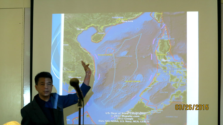
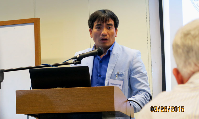
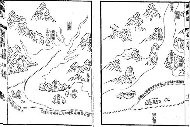
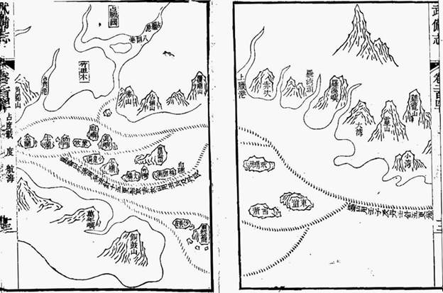
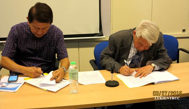